
Abel Tasman National Park’s golden granite coast
Published on 08/18/2026 at 14:09 | Editorial responsibility: Rafael Müller, Editor-in-Chief AD HOC NEWS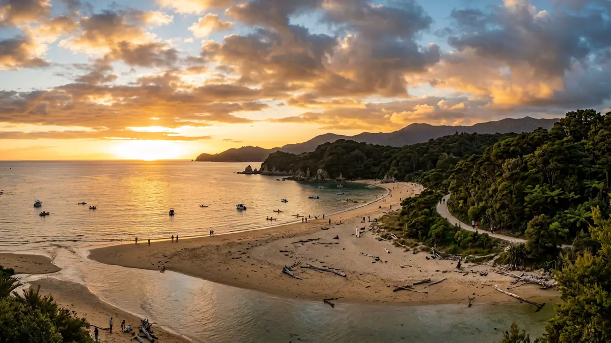
Abel Tasman National Park stretches along the northern edge of New Zealand’s South Island, where forested hills drop towards golden beaches and sheltered bays north of Marahau. Created as a national park in 1942 and named after the seventeenth-century Dutch explorer Abel Tasman, it protects a compact strip of coast between Tasman Bay and Golden Bay that feels shaped by sea, granite and light in equal measure.
Granite headlands, golden sand and clear water
The character of Abel Tasman National Park is defined by the meeting of hard granite headlands and soft, crescent beaches washed by pale-blue water. Measured along the high tide mark, the park’s coastline runs for more than 90 km (56 mi), threading past coves, estuaries and rocky points between Tasman Bay and Golden Bay.the park’s coastline
Much of this shore is carved from Separation Point granite, a pale rock uplifted tens of millions of years ago and now exposed in cliffs, boulders and offshore stacks.Separation Point granite As streams wear the granite down into grains of quartz, feldspar and mica, coarse golden sand forms along the beaches, giving the shoreline its distinctive colour. Against this, the sea on calm days often appears clear enough to show the pale bottom close to shore, especially where bays open gently into Tasman Bay.
A compact coastal park with a long walking route
Abel Tasman National Park covers roughly 22,500 hectares of protected land between Golden Bay / Mohua and Tasman Bay / Te Tai-o-Aorere, making it the smallest of New Zealand’s national parks by area.the smallest of New Zealand’s national parks Within that relatively modest footprint lies a long stretch of coast, backed by hills that rise steeply from sea level into bush-covered ridges and valleys.
Through this landscape runs the Abel Tasman Coast Track, a multi-day walking route that follows the shoreline between Marahau in the south and Wainui Bay in the north.Abel Tasman Coast Track The track links beaches, estuary crossings and forested saddles, with side paths leading down to coves and to simple campsites or huts in bays such as Anchorage and Torrent Bay. Walkers encounter long tidal flats at low water, narrow inlets, and headlands where the path climbs briefly for views over islands, sandspits and the granite-framed coastline.
M?rahau, Kaiteriteri and the making of a national park
Access to Abel Tasman National Park concentrates at its southern end, where the small settlement of M?rahau sits beside Tasman Bay at the start of the Coast Track.the small settlement of M?rahau From here, a formed track enters the park and crosses an estuary before climbing onto the first headlands, while water taxis and sea kayaks depart the nearby waterfront bound for beaches further along the shore.
A second focus lies at Kaiteriteri, a beach settlement south-west of M?rahau where services and accommodation cluster close to the bay.Kaiteriteri Roads also reach Totaranui at the northern end of the main coastal section, while inland tracks connect down from higher country. The protected area itself was formally established in December 1942, following a government decision that year to reserve land on the coast as Abel Tasman National Park, three centuries after Abel Tasman’s voyage through these waters.formally established in 1942
Visiting Abel Tasman National Park: what travellers from Western Europe should know
- Abel Tasman National Park lies at the top of New Zealand’s South Island, between Tasman Bay and Golden Bay, with main access at M?rahau, Kaiteriteri and Totaranui by road.
- The terrain along the coast track alternates between firm beach sand, forest paths with short climbs, and estuary crossings where routes lead across wide tidal flats at low water.
- M?rahau is the closest settlement to the southern park boundary and functions as a gateway village, with a beachfront and visitor facilities clustered near the Coast Track entrance.
- The official language is English and the currency is the New Zealand dollar.
- Entry requirements depend on your nationality; UK travellers can check the FCDO travel advice at gov.uk/foreign-travel-advice, Irish travellers the Department of Foreign Affairs at ireland.ie.
Searching for Abel Tasman National Park on social platforms
These links open searches for Abel Tasman National Park on each platform.
Frequently asked questions about Abel Tasman National Park
Where is Abel Tasman National Park?
Abel Tasman National Park lies on the northern coast of New Zealand’s South Island, between Tasman Bay and Golden Bay, with road access at M?rahau and Totaranui.
What can visitors expect on a first visit?
Visitors encounter a compact coastal landscape of golden sand beaches, granite headlands, estuaries and bush-clad hills linked by the Abel Tasman Coast Track and serviced by boats from nearby settlements.
What makes Abel Tasman National Park distinctive among New Zealand’s parks?
Its relatively small area, long granite coastline, golden sand derived from weathered granite and easy access from villages such as M?rahau give it a coastal character unlike New Zealand’s larger alpine parks.


