
Aillte an Mhothair: Atlantic cliffs on the edge of the Burren
Published on 09/09/2026 at 09:12 | Editorial responsibility: Rafael Müller, Editor-in-Chief AD HOC NEWS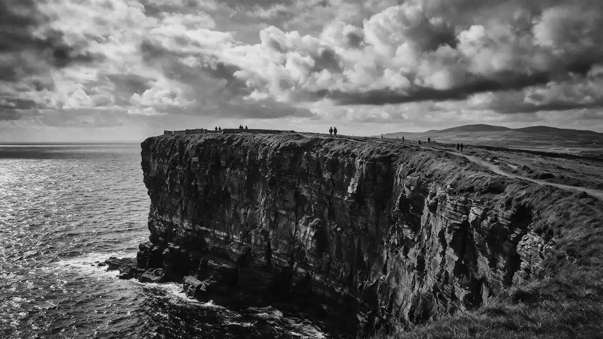
Aillte an Mhothair, on the Atlantic coast near Liscannor in County Clare, is a long stretch of sea cliffs where stratified rock faces drop steeply to the ocean and meet the limestone plateau of the Burren inland. Rising from lower sections at Hag’s Head to a high point where the cliff top stands over 200 m (656 ft) above the waves, this coastal wall forms one of Ireland’s clearest boundaries between land and sea and anchors the Burren and Cliffs of Moher UNESCO Global Geopark in the wider landscape of the west of Ireland.
Atlantic wall of rock along County Clare’s coast
Aillte an Mhothair forms a coastal line of cliffs along the western edge of County Clare, running for around 14 km (9 miles) between the southern headland of Hag’s Head and the higher stretches to the north near O’Brien’s Tower.running for around 14 km At Hag’s Head the rock rises from near sea level to a substantial height above the Atlantic, before gaining elevation towards the central and northern sections where the cliffs reach a maximum height of about 214 m (702 ft) just north of the tower.maximum height of about 214 m
The cliff faces consist mainly of layers of sandstone and shale, formed in the Carboniferous period and exposed in vertical sections that show the stacking of beds over large surfaces.layers of sandstone and shale At the top of the cliffs, the ground shifts to the limestone pavement and grasslands of the Burren, creating a contrast between the darker, banded cliff faces and the lighter limestone surfaces inland.limestone pavement of the Burren Offshore, the Atlantic extends towards the Aran Islands and the wider ocean, while seabirds use the cliff ledges as nesting sites and flight paths along the coast.
O’Brien’s Tower and the Burren and Cliffs of Moher Geopark
Near the midpoint of Aillte an Mhothair stands O’Brien’s Tower, a stone tower built in 1835 by Sir Cornelius O’Brien as a vantage point on the high ground above the cliffs.O’Brien’s Tower built in 1835 From the area around the tower the cliffs reach their greatest height and there are wide views along the line of rock in both directions, over the Atlantic and back towards the inland plateau. The tower itself stands on the cliff top and marks a focal point in many descriptions of the site, linking nineteenth-century interest in coastal vistas with the geological drama of the Atlantic edge.
Aillte an Mhothair forms a central part of the Burren and Cliffs of Moher UNESCO Global Geopark, an internationally recognised area of geological interest designated in 2011.UNESCO Global Geopark since 2011 The Geopark covers around 530 square kilometres of County Clare, with boundaries marked by the Atlantic coast and the inland villages of Tubber, Corofin, Kilfenora and Lisdoonvarna, and it includes sites such as Poulnabrone Dolmen, Doolin Cave and the cliffs themselves.area of 530 square kilometres Within this area, limestone pavements, karst features and coastal cliffs shape a landscape where rock, water and glacial history are directly visible in the terrain.
Rock, ocean and settlements around Liscannor
Aillte an Mhothair lies in the parish of Liscannor in County Clare, with the village of Liscannor to the south and Doolin further north along the coast.parish of Liscannor The cliffs stand on Ireland’s west coast, facing directly onto the Atlantic, and form part of a wider stretch of shoreline that includes bays, headlands and views towards Galway Bay and Loop Head on clear days.views towards Galway Bay and Loop Head Inland, the Burren’s limestone fields extend away from the cliff edge, marked by blocks, fissures and patches of grass and scrub that indicate the thin soils over the rock.
The Irish name Aillte an Mhothair is often translated as “cliffs of ruin” or “cliffs of the ruined fort”, a phrase that reflects historical associations with a fort near the southern end of the cliffs rather than any present structure.Irish name Aillte an Mhothair The cliffs themselves are a product of geological processes acting over millions of years, with marine sediments compacted into rock, raised, and then eroded by waves to form the steep faces seen along the coast. The mixture of sandstone, shale and limestone within short distances makes this area a compact cross-section of several rock types along a single shoreline.
Visiting Aillte an Mhothair: what travellers from Western Europe should know
- Aillte an Mhothair stands on the Atlantic coast of County Clare in western Ireland, near the village of Liscannor to the south and Doolin to the north, reached by road routes from towns such as Ennis and Galway.
- The coastline here consists of high cliff tops above the ocean, with paths that follow the edge of the plateau; sections include gradients and stretches exposed to wind, and cliff-top walking requires attention to footing and proximity to the edge.
- Aillte an Mhothair lies within Ireland, where the official languages are Irish and English and the currency is the euro.
Searching for Aillte an Mhothair on social platforms
These links open searches for Aillte an Mhothair on each platform.
Frequently asked questions about Aillte an Mhothair
Where is Aillte an Mhothair?
Aillte an Mhothair is on Ireland’s Atlantic coast in County Clare, in the parish of Liscannor, with Liscannor to the south and Doolin to the north along the shore.
What can visitors expect at Aillte an Mhothair?
Visitors encounter a long line of high sea cliffs with layered sandstone and shale faces, cliff-top paths above the Atlantic, and views across the Burren plateau and offshore islands.
What makes Aillte an Mhothair distinctive among Irish coastal landscapes?
The combination of over 200 m (656 ft) high cliffs, the presence of O’Brien’s Tower from 1835, and the direct junction with the Burren’s limestone pavements within a UNESCO Global Geopark makes this stretch of coast distinctive.


