
Chichen Itza’s stone calendar city near Valladolid
Published on 09/08/2026 at 09:07 | Editorial responsibility: Rafael Müller, Editor-in-Chief AD HOC NEWS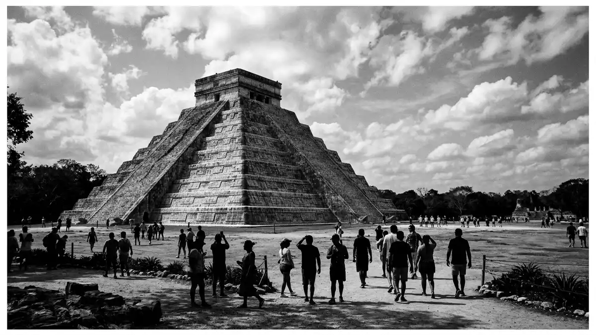
On the low limestone plain of Mexico’s Yucatán Peninsula, Chichen Itza appears as a stone city laid out around a vast ceremonial core, its pyramids and platforms aligned with the sun and stars. The pre-Hispanic city flourished between the ninth and thirteenth centuries as a major centre of Maya and Toltec-Maya civilisation and is inscribed as a UNESCO World Heritage Site, recognised for the scale and preservation of its monuments.Pre-Hispanic city
El Castillo and the stone calendar
The most striking single structure at Chichen Itza is El Castillo, known formally as the Temple of Kukulkán, rising as a stepped pyramid at the centre of the northern platform.Temple of Kukulkán Built between about 1050 and 1300 CE by Toltec-Maya builders, it stands around 30 m (98 ft) high from base to summit temple, on a square platform about 55 m (181 ft) on each side.stepped limestone pyramid Each of its four stairways carries 91 steps, and the top platform forms a final step, giving a total of 365, matching the days of the solar year.
The pyramid’s geometry ties architecture to the Maya calendar in other ways: its nine terraces, split by stairways, echo divisions of the Haab’ solar calendar and longer cycles marked in Maya timekeeping.calendar in stone Around the spring and autumn equinoxes, the late-afternoon sun casts triangular shadows down the main staircase, joining carved serpent heads at the base to form the appearance of a feathered serpent descending the pyramid. The dedication to the deity Kukulkán is visible in these carvings and in the repeated serpent motifs found in neighbouring structures.
Cenotes, platforms and the sacred landscape
Chichen Itza lies in a karst landscape defined by sinkholes, known locally as cenotes, which provided water and formed part of the site’s ritual geography.mouth of the well of the Itza One of the most prominent features is the large, nearly circular sacred cenote to the north of the core buildings, its steep walls dropping to green water used in ceremonies during the city’s heyday. Modern geophysical surveys have identified a substantial cenote beneath El Castillo itself, tying the main pyramid structurally and symbolically to underground water.cenote beneath the pyramid
Around these water-filled depressions stretches an urban-and-ceremonial layout covering several square kilometres, with plazas, raised causeways and grouped platforms.4 square miles The Great Ballcourt, one of several ballcourts on the site, is notable for its length and tall masonry walls, against which stone rings are set high above the playing field. Nearby stand temples decorated with reliefs, a colonnaded complex often called the Temple of the Warriors, and a series of smaller platforms, many bearing carvings of jaguars, eagles and feathered serpents that reflect the city’s mixed Maya and Toltec-Maya artistic vocabulary.Maya-Toltec civilisation
A city on the Yucatán plain
Chichen Itza lies in Tinúm Municipality in the state of Yucatán, roughly between the modern towns of Valladolid and Mérida, on terrain only a little above sea level.Tinúm Municipality, Yucatán The city name is usually translated as “at the mouth of the well of the Itza”, linking it to the local group known as the Itza and to the prominent cenotes at the site.name in Maya language From around the ninth century the settlement developed into a major religious and commercial centre, with architecture that combines earlier Puuc-style elements and later Toltec-Maya forms, most clearly seen in the feathered serpent imagery and columned halls.
The wider zone includes more secluded groups of structures beyond the main northern platform, among them an observatory-like building with a circular tower often referred to as El Caracol, and residential compounds that mark Chichen Itza’s role as a lived-in city as well as a ritual hub.urban centre and ceremonial site The archaeological area is protected as a national park of Mexico and forms part of a wider belt of pre-Hispanic sites across Yucatán that also includes centres such as Uxmal, making the region one of the densest concentrations of ancient monumental architecture in the Americas.World Heritage site
Visiting Chichen Itza: what travellers from Western Europe should know
- Chichen Itza lies in Yucatán state in south-eastern Mexico, inland from the Caribbean coast, reached by road from Valladolid and other towns in the region.
- The monumental core is spread across relatively flat ground, but exploring it involves extended walking over stone and packed-earth surfaces and climbing low masonry platforms.
- The sacred cenote and surrounding vegetation create shaded areas, while large plazas such as those around El Castillo are open to the sky with little shelter.
- The official language is Spanish and the currency is the Mexican peso.
- Entry requirements depend on your nationality; UK travellers can check the FCDO travel advice at gov.uk/foreign-travel-advice, Irish travellers the Department of Foreign Affairs at ireland.ie.
Searching for Chichen Itza on social platforms
These links open searches for Chichen Itza on each platform.
Frequently asked questions about Chichen Itza
Where is Chichen Itza and how does it relate to Valladolid?
Chichen Itza is an archaeological site in Tinúm Municipality in Yucatán state, Mexico, inland from the Caribbean and accessible by road from Valladolid.
What should visitors expect when exploring the site?
Visitors encounter a wide ceremonial core with pyramids, ballcourts, colonnaded halls and cenotes across a spread-out area that requires substantial walking on uneven ground.
What makes Chichen Itza distinctive among ancient cities?
Chichen Itza stands out for El Castillo’s stone calendar pyramid, its large ballcourt, sacred cenotes and the blend of Maya and Toltec-Maya art across the monuments.


