
Farangi Samarias, Kreta’s limestone gorge from plateau to sea
Published on 09/08/2026 at 19:19 | Editorial responsibility: Rafael Müller, Editor-in-Chief AD HOC NEWS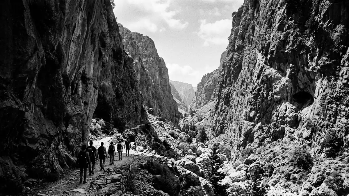
Farangi Samarias, better known in English as the Samaria Gorge, cuts through the White Mountains of western Kreta in Greece as a long limestone corridor running from upland pasture down to the Libyan Sea. The gorge forms the core of the Samaria National Park, a protected area recognised as a Biosphere Reserve under UNESCO’s Man and the Biosphere Programme since 1981, and has been a National Park of Greece since 1962.
A limestone passage through the White Mountains
The physical character of Farangi Samarias is defined by its length and its steady fall from the interior of Kreta towards the island’s south coast. The gorge runs between the high plateau of Omalos in the north and the coastal village of Agia Roumeli on the Libyan Sea, following a line cut into the limestone massif known as the Lefka Ori, or White Mountains.National Park of Greece since 1962 The walkable part of the gorge itself is generally described as around 13 to 16 km in length, with additional shoreline between the mouth of the gorge and the harbour at Agia Roumeli, giving a continuous descent from roughly 1,200 m (3,937 ft) above sea level down to the water’s edge.Lefka Ori in western Crete
The enclosing cliffs rise steeply on either side of the gorge, creating a deep, narrow valley where the rock faces dominate any view along the route. Farangi Samarias is frequently classed among the longest and deepest gorges in Europe, with sources giving figures of around 16 km or more for the main trench and greater distances for the full walk from entrance to exit.13 km main gorge The underlying rock is predominantly limestone, shaped by water erosion into walls, ledges and boulder fields that mark the passage from plateau to sea.
Samaria National Park and its protected landscape
Farangi Samarias sits within the Samaria National Park, an area created in the early 1960s to safeguard the gorge and its surrounding highland ecosystem on Kreta. The park status, combined with its designation as a UNESCO Biosphere Reserve, reflects the diversity of flora and fauna concentrated in the White Mountains and in the gorge itself, including endemic species found only on Kreta such as the wild goat known locally as the kri-kri.UNESCO Biosphere Reserve The protected zone extends beyond the narrowest part of the gorge to cover surrounding slopes, forests and high plateaux.
Along the walking route through Farangi Samarias, the landscape shifts from mountain woodland near Omalos to more open, rocky terrain close to the sea. Descriptions of the path mention stretches through pine and cypress woods, sections beside a seasonal stream, and places where the route passes former settlements such as the village of Samaria itself, long since abandoned but still marked by a handful of buildings and a church.White Mountains forests and villages The protected status of the park limits development along the gorge, leaving the walking track, occasional rest areas and small chapels as the main built structures within its boundaries.
Walking the long descent from Omalos to Agia Roumeli
For visitors, Farangi Samarias is best known as a long, continuous walk that follows the line of the gorge from Omalos down to Agia Roumeli. The usual direction is from north to south, starting at Xyloskalo on the Omalos plateau, where the entrance lies at over 1,200 m (3,937 ft) above sea level, and ending at the coastal hamlet on the Libyan Sea, reached on foot along the stony riverbed and then out to the shoreline.Xyloskalo on the Omalos plateau The route through the gorge itself covers well over 10 km, with descriptions placing the full walking distance, including the final stretch to the harbour, at around 16 to 18 km.
The descent is steep in its upper part, where the path drops from the plateau into the main trench of Farangi Samarias, then continues more gently along the floor of the gorge as it approaches sea level. The terrain combines stone steps, compacted earth, wooden bridges over the stream and sections of loose rock, and the narrowest point of the gorge, sometimes called the “Iron Gates”, compresses the channel between high cliffs into a tight passage where the rock walls stand close on either side.Iron Gates bottleneck By the time the route emerges at Agia Roumeli, the walker has traced the full fall from mountain plateau to open sea in a single day.
Visiting Farangi Samarias: what travellers from Western Europe should know
- Farangi Samarias lies in the south-west of Kreta in Greece, within the regional unit of Chania; the usual walking route runs between the Omalos plateau in the interior and the coastal village of Agia Roumeli on the Libyan Sea, with boat connections onward to other south-coast settlements.
- The terrain inside the gorge demands a sustained walk on uneven ground, including steep descents on stone steps near Xyloskalo, sections over rocks and boulders, and stretches where the path follows the stony riverbed; sturdy footwear and a reasonable level of mountain walking experience are important.
- The route through Farangi Samarias forms part of the longer E4 European long-distance path that crosses Kreta, and waymarking on the established track inside the national park reflects this; however, the gorge itself is remote from road access except at the Omalos entrance and the ferry landing at Agia Roumeli.
- Farangi Samarias lies in Greece, where the official language is Greek and the currency is the euro.
Searching for Farangi Samarias on social platforms
These links open searches for Farangi Samarias on each platform.
Frequently asked questions about Farangi Samarias
Where is Farangi Samarias on Kreta?
Farangi Samarias is in the south-west of Kreta in Greece, within the Chania regional unit, running between the Omalos plateau and the coastal village of Agia Roumeli on the Libyan Sea.
What can travellers expect on a visit to the gorge?
Travellers can expect a long mountain walk through a deep limestone gorge, with steep descents, rocky paths, high cliffs on either side and a final stretch along the shoreline at Agia Roumeli.
What makes Farangi Samarias distinctive among European gorges?
The combination of its considerable length, the full descent from plateau to sea in one continuous route, and its status as the core of the Samaria National Park and a UNESCO Biosphere Reserve gives Farangi Samarias a distinctive place among European mountain gorges.


