
Hakodateyama and the city framed by sea
Published on 09/22/2026 at 20:13 | Editorial responsibility: Rafael Müller, Editor-in-Chief AD HOC NEWS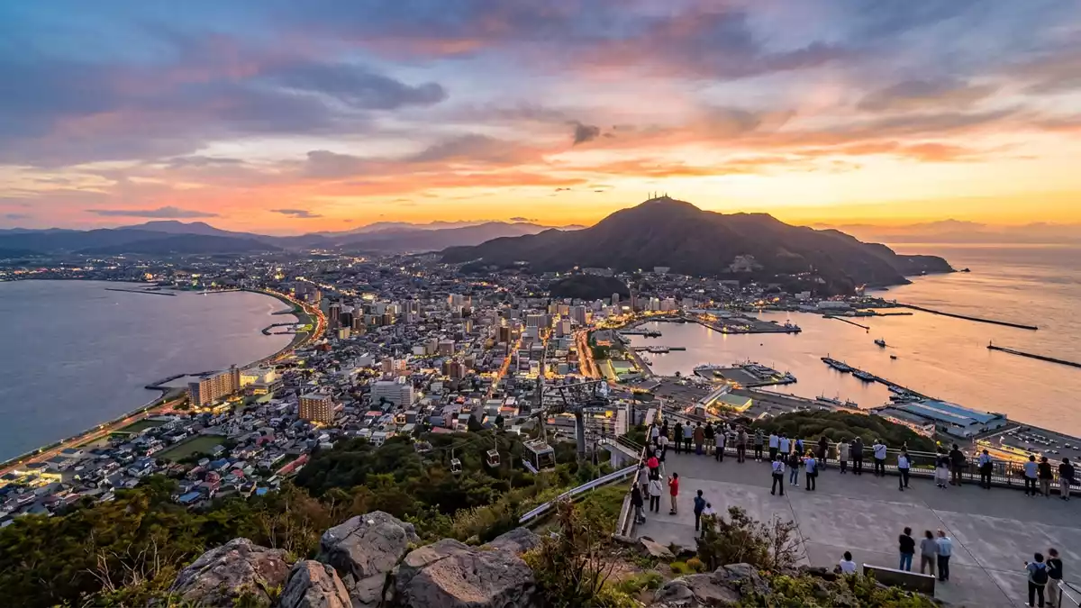
Hakodateyama rises at the southern end of Hakodate, where wooded slopes meet the sea on both sides of the city. From its 334-metre summit, the observatory looks across Hakodate Bay, the Tsugaru Strait and the narrow urban landform between them.
Hakodateyama: a mountain at the end of the city
Hakodateyama is an inactive volcanic mountain on the southern tip of Hokkaido. Its summit belongs to a wooded group of peaks rather than to an isolated cone, and the name Hakodateyama is used for the mountain area as a whole.
Volcanic activity formed the land as an island. Sediment accumulated between the island and the neighbouring peninsula, creating the narrow connection on which central Hakodate stands. The resulting geography is visible from above: the built-up city extends between Hakodate Bay and the open strait, while the mountain occupies the southern end of the peninsula. The 334-metre summit gives the landscape its principal high viewpoint.
From military fortress to public mountain
Hakodateyama also carries the remains of a military landscape. Fortress construction began in 1898, and batteries, observation posts and associated buildings occupied parts of the mountain during the Meiji period and the first half of the twentieth century.
The fortress zone was closed to the public until after the Second World War. Ruins of gun positions and other structures remain among the trees, giving the mountain a second layer beside its natural setting. The surviving traces are connected with the period when Hakodate and the Tsugaru Strait formed part of Japan’s strategic northern frontier. The mountain’s military use ended in 1945, and the area became accessible to the public in the post-war period.
An observatory was established on the summit in 1953. The summit observatory opened in 1953, and the ropeway followed in 1958. These dates mark the change from restricted military ground to a civic and sightseeing landscape.
The ropeway, observatory and night panorama
The Mount Hakodate Ropeway links Motomachi with the summit. Its cabins cross the wooded slope to the upper station, where the observatory occupies the mountain’s highest public viewpoint. The journey itself presents the city as a compressed strip of buildings, roads and water.
The observatory has views in daylight and after dark. Hakodate Bay lies on one side of the urban peninsula, while the Tsugaru Strait opens on the other. Street lighting and harbour illumination form a pattern below, with the darker mountain edge behind the viewpoint. The scene is a direct expression of Hakodate’s geography rather than a separate city skyline.
The Mount Hakodate Ropeway has connected the base and summit since 1958. A path also leads uphill, and buses provide another route to the mountain area. Around the summit, the forest, open viewpoints and fortress remains occupy the same compact landscape.
Visiting Hakodateyama: what travellers from Western Europe should know
- Hakodateyama rises south of central Hakodate. The Hakodate City Tram reaches Jujigai, followed by a walk to the ropeway station in Motomachi.
- The mountain reaches 334 m (1,096 ft). The summit can be reached by ropeway, bus or a walking path.
- Forest surrounds the summit facilities, and surviving fortress batteries and other military ruins stand along parts of the mountain.
- The official language is Japanese and the currency is the Japanese yen.
- Entry requirements depend on your nationality; UK travellers can check the FCDO travel advice at gov.uk/foreign-travel-advice, Irish travellers the Department of Foreign Affairs at ireland.ie.
Searching for Hakodateyama on social platforms
These links open searches for Hakodateyama on each platform.Frequently asked questions about Hakodateyama
Where is Hakodateyama?
Hakodateyama is at the southern end of Hakodate on Hokkaido, Japan. The mountain stands between the city and the waters of Hakodate Bay and the Tsugaru Strait.
What can visitors see there?
Visitors can see the summit observatory, wooded slopes, views across Hakodate and remains of the former fortress. The mountain can be reached by ropeway, bus or walking path.
What makes Hakodateyama distinctive?
Its 334-metre summit combines a volcanic landscape, a former military zone and a city panorama framed by two bodies of water. The observatory and ropeway date from the public-access period after 1953.


