
Isla del Sol: Lake Titicaca’s island of terraces and trails
Published on 09/12/2026 at 14:46 | Editorial responsibility: Rafael Müller, Editor-in-Chief AD HOC NEWS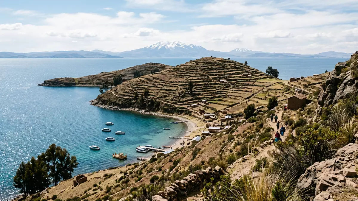
On the Bolivian side of Lake Titicaca, Isla del Sol lifts out of deep blue water as a stepped landscape of agricultural terraces, stone paths and scattered ruins, a short boat journey from Copacabana yet feeling like a separate highland world. The island sits within the La Paz Department and forms part of the Manco Kapac Province, a place where pre-Columbian settlement and Andean village life share the same rocky slopes.island in the Bolivian sector
Lake island shaped by terraces and altitude
Isla del Sol lies in the southern part of Lake Titicaca, just north-west of the Copacabana peninsula on the Bolivian shore, surrounded by cold, high-altitude water and distant Andean ridges.southern part of Lake Titicaca The lake surface stands at around 3,810 m (12,500 ft) above sea level, with the island’s higher points rising further above the water and giving wide views over the surrounding mountains and peninsulas.lake level 3,810 m
The island covers about 14.3 square kilometres (5.5 sq mi), with a long north–south profile that visitors experience most directly on the ridge-top footpath linking the northern and southern settlements.area of 14.3 square km Agricultural terraces cut into the slopes create horizontal bands of stone and earth, and small fields drop in stages towards the shore, while simple houses and paths cluster around the hamlets of Yumani in the south, Cha’lla in the centre and Challapampa in the north.three small Aymara-speaking communities
Traces of Inca and earlier cultures along the ridge
Long before modern travellers arrived, Isla del Sol formed part of a dense web of Andean ritual and settlement, with evidence of human occupation dating back to around 2,200 BCE and continuing through Formative periods into a Tiwanaku presence and then the rise of the Inca Empire.continuous human occupation from around 2200 BCE The island later became a significant Inca pilgrimage centre, with terraced agriculture and stone structures built into the slopes, and archaeological surveys have identified numerous sites scattered across its surface.contains over 80 known archaeological sites
On the northern side, near Challapampa, the Chincana ruins preserve the remains of a substantial Inca settlement and palace complex dating largely to the fifteenth century, during the period when Topa Inca Yupanqui extended imperial control across this part of the Andes.Chincana ruins date to the 15th century Various origin stories of the Inca rulers connect them with this island and Lake Titicaca, giving Isla del Sol a strong place in regional mythology even as the visible experience today is defined by roofless walls, terraces and carved stones.
Walking Isla del Sol: stone paths between lake and sky
For visitors approaching from Copacabana, the journey to Isla del Sol is defined by the boat crossing and the first steep climb up from the small harbours at Yumani or Challapampa, where stone steps and paths quickly gain height above the lake.boat from Copacabana The main north–south route follows the spine of the island for around 10 to 12 km (6 to 7.5 mi), crossing open slopes, terraced sections and small settlements, with long stretches on exposed ridges where the water lies far below on both sides.ridge route roughly 10–12 km
Life on Isla del Sol revolves around agriculture, small-scale herding and community-based tourism, and the absence of cars on the island means that every movement takes place on foot along paths that have served local communities for generations.small, car-free island Simple accommodation and eateries cluster near the main arrival points and village centres, and many visitors structure their time around the ridge walk, shorter local loops to ruins or viewpoints, and moments watching light change over Lake Titicaca from the upper terraces.
Visiting Isla del Sol: what travellers from Western Europe should know
- Isla del Sol lies off the Copacabana peninsula in Lake Titicaca, Bolivia, and is reached by boat services running from Copacabana’s lakeside pier to harbours such as Yumani and Challapampa.
- The island rises above a lake already at about 3,810 m (12,500 ft), and paths between villages and ruins involve sustained climbs on stone steps and uneven terraces.
- The official language is Spanish alongside Aymara in local communities, and the currency is the Bolivian boliviano.
- Entry requirements depend on your nationality; UK travellers can check the FCDO travel advice at gov.uk/foreign-travel-advice, Irish travellers the Department of Foreign Affairs at ireland.ie.
Searching for Isla del Sol on social platforms
These links open searches for Isla del Sol on each platform.
Frequently asked questions about Isla del Sol
Where is Isla del Sol in relation to Copacabana?
Isla del Sol lies just north-west of the Copacabana peninsula on the Bolivian side of Lake Titicaca, within the La Paz Department and Manco Kapac Province.
What should visitors expect on a visit to Isla del Sol?
A visit centres on boat travel from Copacabana, steep stone paths up from small harbours, high-altitude walking between villages and ruins, and open views over Lake Titicaca.
What makes Isla del Sol distinctive among Lake Titicaca destinations?
Isla del Sol combines continuous human occupation stretching back millennia with visible Inca-period ruins, agricultural terraces and car-free ridge paths linking its small Aymara-speaking communities.


