
Jokulsarlon: ice, ocean and black sand in southeast Iceland
Published on 08/23/2026 at 14:10 | Editorial responsibility: Rafael Müller, Editor-in-Chief AD HOC NEWS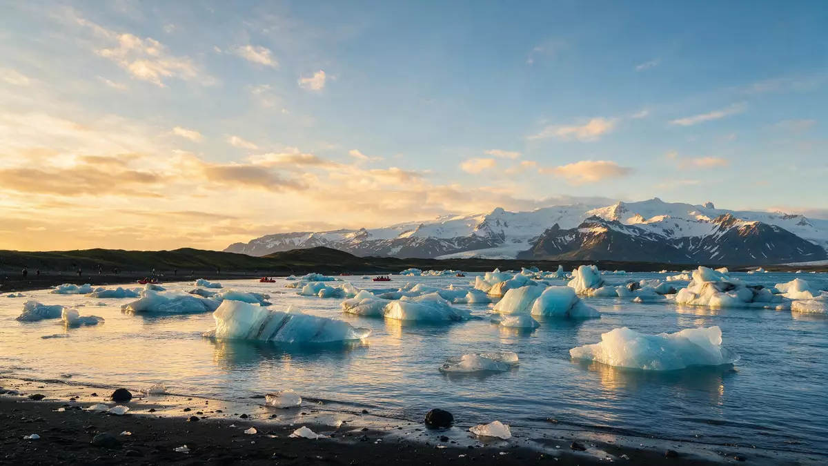
Jokulsarlon is a glacial river lagoon on the southern edge of Vatnajokull National Park in southeast Iceland, where pale icebergs drift past black sand towards the Atlantic Ocean. Formed in the twentieth century as outlet glaciers retreated, it has become one of Iceland’s deepest lakes and a striking meeting point of ice, seawater and volcanic shoreline.
A lagoon at the foot of Breidamerkurjokull
Jokulsarlon lies at the seaward end of the Breidamerkurjokull glacier tongue, part of the vast Vatnajokull ice cap that covers much of eastern and southern Iceland.Breidamerkurjokull glacier descends from the interior highlands towards the coastal plain, and the lagoon occupies the low-lying basin where the glacier front has pulled back from the ocean. The water is a mix of meltwater from the ice and seawater drawn in with the tides through the short channel that links the lagoon to the Atlantic.
The lake itself has grown markedly since the early twentieth century, expanding from a small pool into a body of water that covers more than 10 square kilometres (3.9 sq mi) and reaches depths well over 200 m (656 ft). Satellite measurements and local surveys describe Jokulsarlon as one of the deepest lakes in Iceland, a status that reflects how far the glacier has withdrawn. The surrounding landscape shows low moraine ridges and dark sand flats, reminders that the lagoon occupies ground once filled by moving ice.
Icebergs, tides and the pull of the sea
The most immediate feature at Jokulsarlon is the field of free-floating icebergs that break away from the glacier front and drift across the lagoon. They vary in size from small blocks to towering pieces several storeys high, with surfaces ridged and banded by ash layers that record earlier volcanic eruptions beneath the ice.Icebergs calving from Breidamerkurjokull form continuously, and some of the ice within them is thought to have compacted in the glacier more than 1,000 years ago.
A narrow man-made channel connects Jokulsarlon with the Atlantic, carrying water and broken ice between the lagoon and the open sea.The channel is affected by the tides, so water levels rise and fall by a couple of metres each tidal cycle, and blocks of ice move back and forth before eventually escaping into the ocean. Many of those pieces are then washed ashore on the neighbouring beach, where they come to rest on dark volcanic sand and slowly melt. The contrast between clear or milky-blue ice and black shore gives this stretch of coast its “Diamond Beach” nickname.
Part of Vatnajokull National Park and Iceland’s glacial story
Jokulsarlon sits within the protected area of Vatnajokull National Park, which was established to safeguard Iceland’s largest ice cap and the landscapes shaped by it.The lagoon forms one of the coastal gateways where visitors can see the direct meeting of outlet glacier, lake and ocean in one place. The park covers glaciers, volcanoes and extensive sand plains, and Jokulsarlon stands on the seaward fringe of this broad terrain.
The lagoon itself began to form in the first half of the twentieth century as temperatures rose and Breidamerkurjokull withdrew from the shore.Accounts from the mid twentieth century describe a depression filling with meltwater where the glacier once met the main coastal road, growing into a lake that has continued to enlarge over the decades. Historical images and modern satellite records together show Jokulsarlon expanding severalfold in area since about 1970, turning from a narrow inlet into a wide lagoon scattered with ice.
Visiting Jokulsarlon: what travellers from Western Europe should know
- Jokulsarlon lies beside Iceland’s Route 1 (Ring Road) on the southern coastline between Skaftafell and Hofn, in the southeast of the country. Travellers approaching from Reykjavik follow the Ring Road east across the south coast.
- The shoreline around the lagoon combines soft volcanic sand with rough, uneven ground shaped by glacial deposits, so sturdy footwear is helpful for walking near the water and on the beach.
- The closest small town is Hofn on the eastern side of the lagoon area, while Skaftafell and Kirkjubaejarklaustur lie to the west along the same road.
- The official language is Icelandic and the currency is the Icelandic krona.
- Entry requirements depend on your nationality; UK travellers can check the FCDO travel advice at gov.uk/foreign-travel-advice, Irish travellers the Department of Foreign Affairs at ireland.ie.
Searching for Jokulsarlon on social platforms
These links open searches for Jokulsarlon on each platform.
Frequently asked questions about Jokulsarlon
Where is Jokulsarlon in Iceland?
Jokulsarlon is on the southern coastline of Iceland in the southeast of the country, beside Route 1 between Skaftafell and Hofn, at the edge of Vatnajokull National Park.
What should visitors expect on a visit to Jokulsarlon?
Visitors encounter a glacial lake scattered with icebergs, dark volcanic sand and views towards the Breidamerkurjokull glacier front, with changing patterns of ice as pieces calve and drift.
What makes Jokulsarlon distinctive among Iceland’s glacial landscapes?
Jokulsarlon is distinctive because outlet glacier, deep lagoon, tidal channel and open Atlantic shoreline meet in one compact area, creating a rare combination of drifting ice and black sand coast in direct view.


