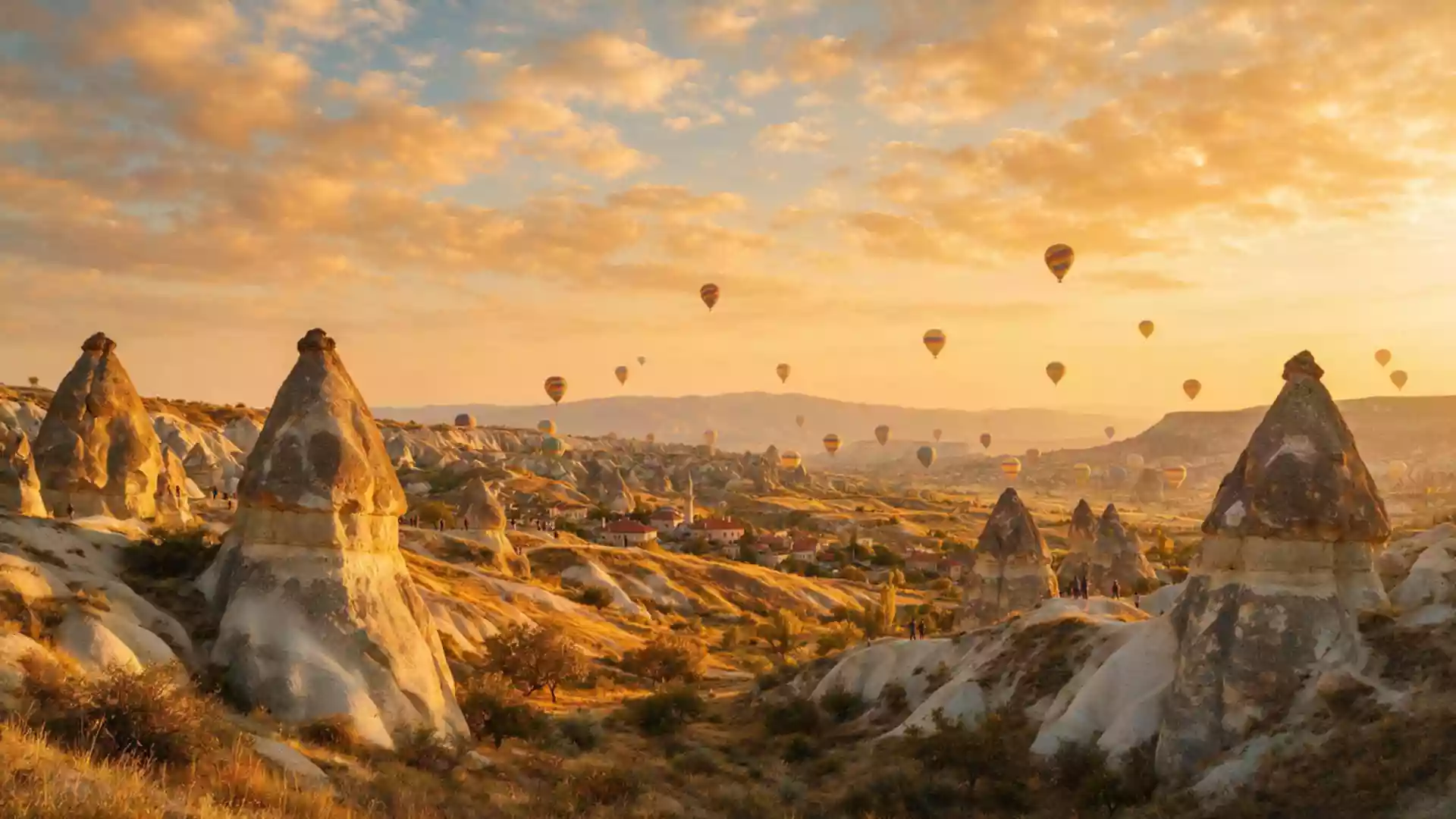
Kapadokya around Göreme and its sculpted volcanic landscape
Published on 08/22/2026 at 10:12 | Editorial responsibility: Rafael Müller, Editor-in-Chief AD HOC NEWS
Kapadokya around Göreme in central Turkey is a landscape shaped in depth by volcanic rock, erosion and human carving, where valleys of fantastical formations meet cave churches set into the stone. Göreme lies in Nev?ehir Province on the Central Anatolia plateau, within an area recognised as Göreme National Park and the Rock Sites of Cappadocia on the UNESCO World Heritage List since 1985.Göreme National Park and the Rock Sites of Cappadocia
Volcanic tuff, erosion and the “fairy chimney” valleys
Kapadokya’s distinctive forms around Göreme begin with the underlying geology: a volcanic landscape built up by eruptions from Central Anatolian volcanoes such as Mount Erciyes and Mount Hasan, then worn away by wind and water. Layers of soft volcanic tuff sit beneath harder caps of rock, and erosion has carved them into slender pillars, pinnacles and ridges that rise from the plateau in clusters known as “fairy chimneys”.volcanic region of Mount Hasan and Mount Erciyes Around Göreme these formations line valleys that cut into the plateau, creating a terrain of narrow defiles, wider basins and steep slopes where rock faces appear in bands of pale cream and honey tones.
The World Heritage property that includes Göreme covers a mosaic of valleys and rock sites between Nev?ehir, Ürgüp and Avanos, along with underground settlements such as Derinkuyu and Kaymakl?.the region between the cities of Nev?ehir, Ürgüp and Avanos Within this broader protected landscape, the Göreme Historical National Park occupies nearly 100 km² (39 sq mi), giving formal protection to the sculpted tuff scenery and the rock-cut architecture it contains.Göreme Historical National Park occupies nearly 100 km² The result around Göreme is a countryside where slopes and valley floors are punctuated by shafts of stone, clusters of cones and cliff faces that have been modified by human hands over many centuries.
Cave churches, monastic life and Byzantine painting in the rock
Beyond their unusual shapes, the tuff formations around Göreme carry a dense layer of cultural history in the form of rock-cut sanctuaries, monastic complexes and dwellings carved directly into the stone. The Göreme valley and its surroundings contain churches and chapels that bear frescoes from the post-Iconoclastic Byzantine period, representing one of the clearest surviving clusters of painted Christian interiors preserved within caves and carved rooms.rock-hewn sanctuaries that provide evidence of Byzantine art These sanctuaries form part of a wider pattern of troglodyte villages and monastic settlements scattered through the valleys and along the flanks of the plateau.
Just outside Göreme, the Göreme Open Air Museum brings many of these features together in one accessible area, with a cluster of rock-cut churches, chapels and monastic spaces connected by paths across the tuff slopes.Goreme Open Air Museum is a cluster of rock-cut Byzantine churches Interiors within this cluster include barrel-vaulted halls, carved columns, niches and altars cut from the rock, with walls and ceilings painted in scenes from Christian iconography. Across the broader National Park, rock-cut structures extend to multi-level underground cities such as Kaymakl? and Derinkuyu, where passages, rooms and stairways descend through the tuff, illustrating how communities made long-term use of the soft volcanic geology.subterranean cities of Kaymakl? and Derinkuyu
Göreme town on the plateau and its setting in Nev?ehir Province
Göreme itself is a town in the Nev?ehir District of Nev?ehir Province in Central Anatolia, Turkey, with a population recorded in the low thousands and a setting at a plateau altitude around 1,100 m (3,609 ft) above sea level.Göreme is a town in the Nev?ehir District The town sits within the boundaries of Göreme Historical National Park, so houses, small hotels and local streets stand among outcrops of tuff and carved rock faces rather than in isolation from them.Göreme is the main tourist centre in Cappadocia From Göreme, paths lead directly into neighbouring valleys where the landscape opens into wider views of the plateau and its carved forms.
The protected area that includes Göreme is officially recognised as Göreme National Park and the Rock Sites of Cappadocia, with inscription on the UNESCO World Heritage List dating to 1985 under both natural and cultural criteria.inscribed on the World Heritage List in 1985 Within Nev?ehir Province the National Park stretches between Nev?ehir, Ürgüp and Avanos, taking in multiple valleys and rock-cut sites as well as the underground cities associated with the wider Kapadokya region.Göreme valley and its surroundings contain troglodyte villages The combination of carved settlements, painted cave churches and the surrounding volcanic scenery gives Göreme a character tied closely to both the plateau and the long history of settlement in this part of Central Anatolia.
Visiting Kapadokya: what travellers from Western Europe should know
- Kapadokya around Göreme lies in Nev?ehir Province in Central Anatolia, Turkey, and is reached by road connections from nearby centres such as Nev?ehir and Kayseri, with Göreme functioning as a hub for exploring the surrounding valleys.
- Terrain around Göreme includes slopes of soft volcanic tuff and valley paths that can involve uneven surfaces and gradients, with approaches to some cave churches and viewpoints following tracks across the rock and among the fairy chimney formations.
- Göreme sits at plateau elevation in Central Anatolia, and paths leading out of the town into the National Park may involve walking between rock faces and through narrow valley sections where the carved tuff landscape is close at hand.
- The official language is Turkish and the currency is the Turkish lira.
- Entry requirements depend on your nationality; UK travellers can check the FCDO travel advice at gov.uk/foreign-travel-advice, Irish travellers the Department of Foreign Affairs at ireland.ie.
Searching for Kapadokya on social platforms
These links open searches for Kapadokya on each platform.
Frequently asked questions about Kapadokya
Where is Kapadokya around Göreme located?
Kapadokya around Göreme lies in Nev?ehir Province in Central Anatolia, Turkey, within Göreme Historical National Park and the wider Göreme National Park and Rock Sites of Cappadocia.
What can visitors expect when exploring the area?
Visitors encounter valleys of sculpted volcanic tuff, clusters of fairy chimney formations, rock-cut churches with Byzantine frescoes, and a town whose streets are closely integrated with the surrounding carved landscape.
What makes Kapadokya around Göreme distinctive among Anatolian landscapes?
The combination of volcanic geology, erosion-shaped pinnacles, extensive rock-cut settlements and sanctuaries, and its inscription as a mixed natural and cultural UNESCO World Heritage Site gives Kapadokya around Göreme a character closely tied to both stone and history.