
Lineas de Nazca: drawings across a desert plain
Published on 09/22/2026 at 22:30 | Editorial responsibility: Rafael Müller, Editor-in-Chief AD HOC NEWS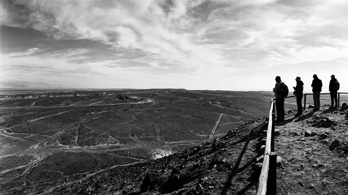
Lineas de Nazca are immense drawings cut into the desert near Nazca in southern Peru. Animal figures, plants, geometric forms and long straight lines occupy an arid plain whose full scale becomes clear from above.
Lines written across the Pampa Colorada
The geoglyphs lie on the Pampa Colorada, northwest of Nazca, within the coastal desert of southern Peru. The wider archaeological landscape extends across the basin of the Rio Grande de Nazca and reaches towards Palpa.
The protected area covers about 450 km² (174 sq miles), while the formal World Heritage property extends across approximately 75,358 hectares. Its designation is Lines and Geoglyphs of Nasca and Palpa, inscribed on the UNESCO World Heritage List in 1994.
Animals, plants and geometric figures
The designs include a monkey, spider, hummingbird, condor, pelican, killer whale and plant forms. Their dimensions vary sharply: the hummingbird measures about 50 m (164 ft), while the pelican extends to roughly 285 m (935 ft).
Other figures include triangles, trapezoids and spirals. The lines themselves cross the desert in long sweeps, while cleared areas and broad geometric shapes sit beside the figurative drawings. From ground level, many designs appear as shallow paths or changes in the surface; from the air, their outlines form recognisable images.
Paracas and Nazca cultures on the desert floor
The geoglyph tradition belongs to the ancient societies of Peru’s southern coast. Some designs predate the Nazca culture and are associated with the Paracas culture, while many animal and plant figures belong to the Nazca period.
The main phase of Nazca culture is dated to about 200 BC–600 AD. The broader line tradition spans a longer period, with examples dated between the eighth century BC and the eighth century AD. The ground drawings therefore represent several centuries of activity across a shared desert landscape. Their precise purpose remains unresolved, while their forms and placement remain visible as archaeological features.
The surface consists of dark desert stones over lighter ground. Removing the upper stones exposes contrasting soil, creating the lines and outlines. The dry coastal climate has preserved this difference across generations, leaving the designs legible over an expansive plateau.
Visiting Lineas de Nazca: what travellers from Western Europe should know
- Lineas de Nazca lie in the Ica Region, about 400 km (249 miles) south of Lima, near the city of Nazca. The Pan-American Highway connects Lima, Ica and Nazca by road.
- The desert plain is broad and open, with no single ground-level viewpoint covering the full group of figures. A viewing tower beside the Pan-American Highway overlooks selected geoglyphs.
- Flights over the geoglyphs depart from the area around Nazca and reveal the large animal figures, geometric forms and long lines from above.
- The official language is Spanish and the currency is the Peruvian sol.
- Entry requirements depend on your nationality; UK travellers can check the FCDO travel advice at gov.uk/foreign-travel-advice, Irish travellers the Department of Foreign Affairs at ireland.ie.
Searching for Lineas de Nazca on social platforms
These links open searches for Lineas de Nazca on each platform.
Frequently asked questions about Lineas de Nazca
Where are Lineas de Nazca?
They lie in southern Peru, near Nazca, on the arid coastal plain of the Ica Region. The wider site extends between the areas of Nazca and Palpa.
What can visitors expect?
The desert contains shallow lines, broad geometric forms and large animal figures. A tower provides a ground-level view of selected designs, while flights show their complete outlines.
What makes the geoglyphs distinctive?
The drawings combine immense scale with simple contrasts in the desert surface. Their subjects include animals and plants, alongside long lines, triangles, trapezoids and spirals.


