
Okavango Delta, where a river ends in desert sands
Published on 09/23/2026 at 21:13 | Editorial responsibility: Rafael Müller, Editor-in-Chief AD HOC NEWS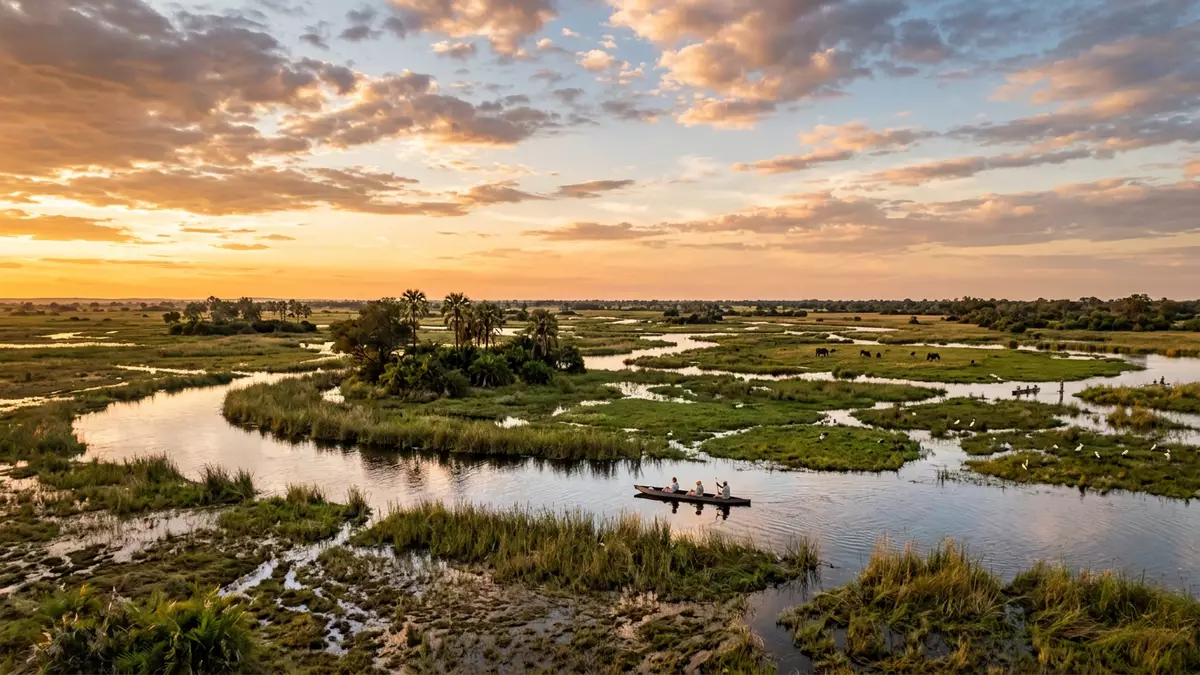
Okavango Delta is a vast inland wetland in north-western Botswana, linked with Maun on its southern edge. The Okavango River spreads across marshes, channels, islands and seasonally flooded grasslands, then drains into the sands of the Kalahari Basin instead of reaching the sea.
This unusual geography gives the delta its defining visual contrast: clear waterways and green floodplains set within an arid landscape. Its World Heritage property covers 2,023,590 hectares, while the wider wetland extends across a larger Ramsar site.
Okavango Delta: a river without a sea outlet
The Okavango Delta is an alluvial fan, a broad, low-gradient landform created by river sediments. The Okavango River rises in the Angolan highlands, crosses the basin shared by Angola, Namibia and Botswana, and reaches the delta in the north-west of Botswana.
Instead of following a channel towards an ocean, the river divides across the Kalahari Basin. Permanent swamps, seasonal floodplains, lagoons, lakes and waterways form a shifting wetland mosaic. the inland delta landscape is part of a nearly intact wetland system.
The flood cycle gives the delta a distinctive seasonal rhythm. Water from the Angolan headwaters reaches Botswana during the dry season, when much of the surrounding region is dry. Plants and animals are adapted to this timing, with growth, breeding and movement linked to the arrival and retreat of floodwater.
Channels, islands and wildlife habitats
The delta is not a single sheet of water. Its habitats include permanent and seasonal rivers, lagoons, swamps, flooded grasslands, dry woodland, riparian forest and islands. Channels divide and reconnect across floodplains, while islands provide areas of dry ground among the wetlands.
The World Heritage property contains 1,061 plant species, 89 fish species, 64 reptiles, 482 bird species and 130 mammal species. Its wildlife includes elephant, buffalo, red lechwe, hippopotamus, crocodile, lion, leopard, cheetah and African wild dog.
The delta also supports white and black rhinoceros, both threatened species. Birds include wattled crane, southern ground-hornbill, slaty egret and several vulture species. These habitats create space for aquatic animals, grassland species and woodland wildlife within the same broad wetland.
Moremi Game Reserve occupies part of the protected landscape, alongside Wildlife Management Areas and community-managed land. The delta has also been inhabited for centuries by indigenous communities, including the Wayeyi, Hambukushu and San, whose livelihoods have included fishing, hunting, gathering and flood-recession farming.
World Heritage, Ramsar protection and Maun
The Okavango Delta became a Wetland of International Importance on 12 September 1996. It was inscribed as a natural World Heritage property in 2014, recognising its landscape, ecological processes and biodiversity. its 1996 Ramsar designation forms part of the delta’s international conservation history.
The UNESCO property covers permanent swamps and seasonally flooded grasslands across 2,023,590 hectares, with a buffer zone of 2,286,630 hectares. The larger Ramsar site covers 5,537,400 hectares and extends beyond the World Heritage boundaries.
These designations describe different aspects of the same wetland. World Heritage status recognises the interaction of climate, geology, water and biological life. Ramsar status identifies the delta as an internationally important wetland supporting habitats, waterbirds and threatened species.
Maun is the principal urban gateway to the delta and lies south of its wetland channels. The town connects the dryland edge with safari areas, community lands and waterways. Travel through the delta can involve light aircraft, four-wheel-drive routes, motorboats and mokoro dugout canoes, depending on the landscape and destination.
Visiting Okavango Delta: what travellers from Western Europe should know
- Okavango Delta lies in north-western Botswana, north of Maun. Maun is the principal access town, with air links and road connections towards the delta.
- The landscape alternates between dry sand, shallow channels, permanent swamps, floodplains and islands. Boat travel and mokoro excursions take place on waterways, while some areas are reached across sandy terrain.
- The official language is English and the currency is the Botswana pula.
- The Okavango River begins in Angola and passes through Namibia before reaching Botswana. Water levels and flood patterns vary across the delta.
Searching for Okavango Delta on social platforms
These links open searches for Okavango Delta on each platform.
Frequently asked questions about Okavango Delta
Where is Okavango Delta?
Okavango Delta is in north-western Botswana, with Maun on its southern side. The wetland forms part of the Kalahari Basin and receives water from the Okavango River.
What can visitors expect in the delta?
Visitors encounter waterways, lagoons, marshes, flooded grasslands, islands and dry woodland. Safaris may involve boats, mokoro canoes, vehicles or light aircraft.
What makes Okavango Delta distinctive?
Its river ends inland, without an outlet to the sea. Annual flooding reaches Botswana during the dry season, supporting habitats and wildlife in an otherwise arid region.


