
Ribeira, Porto’s stacked riverfront old town
Published on 08/16/2026 at 14:57 | Editorial responsibility: Rafael Müller, Editor-in-Chief AD HOC NEWS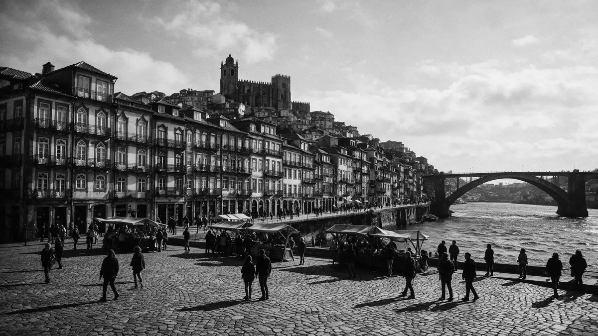
Ribeira is the riverside quarter where Porto’s old town leans down to meet the Douro, a dense patchwork of stacked houses, cobbled lanes and riverfront arcades that form part of the city’s UNESCO-listed historic centre. Set on the north bank of the Douro River in Portugal, this medieval district grew as Porto’s original waterfront settlement and still carries the fabric of an historic harbour within its streets and squares.
Riverside quarter between hillside and Douro
Ribeira occupies the lower slope of Porto’s historic centre, pressed between the Douro River and the streets that climb towards the Sé cathedral and the upper town. The quarter runs along the north bank of the river from near the Dom Luís I Bridge towards landmarks such as Casa do Infante and the old customs building, forming a continuous waterfront lined with old houses and arcaded ground floors.Ribeira sits at the base of Porto's hillside city The district’s name comes from the Portuguese word for riverbank, and its streets drop steeply from the higher ground to the quay, creating tight vistas framed by tall façades.
At the water’s edge lies Cais da Ribeira, the main riverfront promenade where the quayside once handled cargo from the Douro Valley and Atlantic trade. The promenade links the foot of the Dom Luís I Bridge with Praça da Ribeira, a square that opens directly onto the river and acts as a focal point for the neighbourhood.Cais da Ribeira connects the bridge with Praça da Ribeira On the opposite bank, Vila Nova de Gaia rises with its historic port wine lodges, so the waterfront views combine stacked townhouses, river traffic and the iron span of the bridge.
UNESCO-listed historic centre and waterfront fabric
Ribeira forms part of the “Historic Centre of Porto, Luiz I Bridge and Monastery of Serra do Pilar”, the ensemble inscribed on the UNESCO World Heritage List in 1996.The historic centre including Ribeira was inscribed on 5 December 1996 The listing recognises Porto’s historic core as an urban landscape shaped by nearly two millennia of settlement and by a long relationship with maritime trade and port wine. Within that core, Ribeira preserves a medieval street grid that descends to the river, along with later additions such as Baroque churches and 19th-century iron bridges visible from the quay.Ribeira's UNESCO designation forms part of Porto's historic centre
The buffer zone for the World Heritage site covers the area from the Sé cathedral down to the riverside and across the Douro to the Monastery of Serra do Pilar and Vila Nova de Gaia, tying the riverfront to the opposite bank where port wine has long been stored and matured.The buffer zone covers 49 hectares from the Cathedral down to the riverside Around Ribeira, sections of the 14th-century Muralha Fernandina defensive wall remain visible above the rooftops, reminders that this working waterfront once lay within fortified medieval Porto.The Muralha Fernandina defensive wall stands above Ribeira's roofline
Stacked houses, steep lanes and riverside life
Ribeira’s character lies in its physical fabric: tall, narrow houses crowd the riverbank and the hillside behind, their façades finished in painted plaster, stone and traditional azulejo tiles. Many buildings have balconies with wrought-iron railings and laundry hung above the street, while ground floors open as cafés, small shops and restaurants under arcades or awnings.Ribeira is one of the most ancient and typical sites of the city Away from the waterfront, lanes such as Rua da Fonte Taurina and Rua da Lada climb in tight curves, flanked by old houses whose upper storeys sometimes overhang the street.
Praça da Ribeira, the riverside square, sits among these façades as an open space where the riverfront and the inner streets meet. From the square, views reach across the Douro to Gaia and up towards the higher quarters of Porto, with Dom Luís I Bridge cutting a double-decked arch across the river.Praça da Ribeira lies at the centre of Porto's riverside quarter Along the quay, traditional barcos rabelos, the historic wooden boats once used to transport port wine downstream, are moored as a reminder of the river trade that shaped the district.Barcos rabelos are moored along the riverside
Visiting Ribeira: what travellers from Western Europe should know
- Ribeira lies on the north bank of the Douro River below Porto’s historic upper town and near the Dom Luís I Bridge; São Bento railway station and the Sé cathedral stand uphill within walking distance.
- The quarter’s streets are steep and narrow, with cobbled surfaces and stairways linking the upper town to the riverfront, so moving around involves gradients and steps rather than level boulevards.
- Closer to the Douro, the riverfront promenade at Cais da Ribeira offers long, level stretches beside the water, with open views towards Vila Nova de Gaia and the iron span of Dom Luís I Bridge.
- The official language is Portuguese and the currency is the euro.
Searching for Ribeira on social platforms
These links open searches for Ribeira on each platform.
Frequently asked questions about Ribeira
Where is Ribeira in Porto?
Ribeira is the lower riverside district of Porto on the north bank of the Douro River, directly below the historic upper town and near the Dom Luís I Bridge.
What should visitors expect when walking through Ribeira?
Visitors encounter steep cobbled lanes, stacked old houses and a busy riverfront promenade at Cais da Ribeira, with squares such as Praça da Ribeira opening onto views across the Douro.
What makes Ribeira distinctive among Porto’s districts?
Ribeira combines a medieval street grid, riverside harbour heritage and UNESCO recognition within a compact area where historic houses, traditional boats and major landmarks like Dom Luís I Bridge share the same riverfront stage.


