
Trolltunga: Norway’s horizontal cliff above Ringedalsvatnet
Published on 08/16/2026 at 14:03 | Editorial responsibility: Rafael Müller, Editor-in-Chief AD HOC NEWS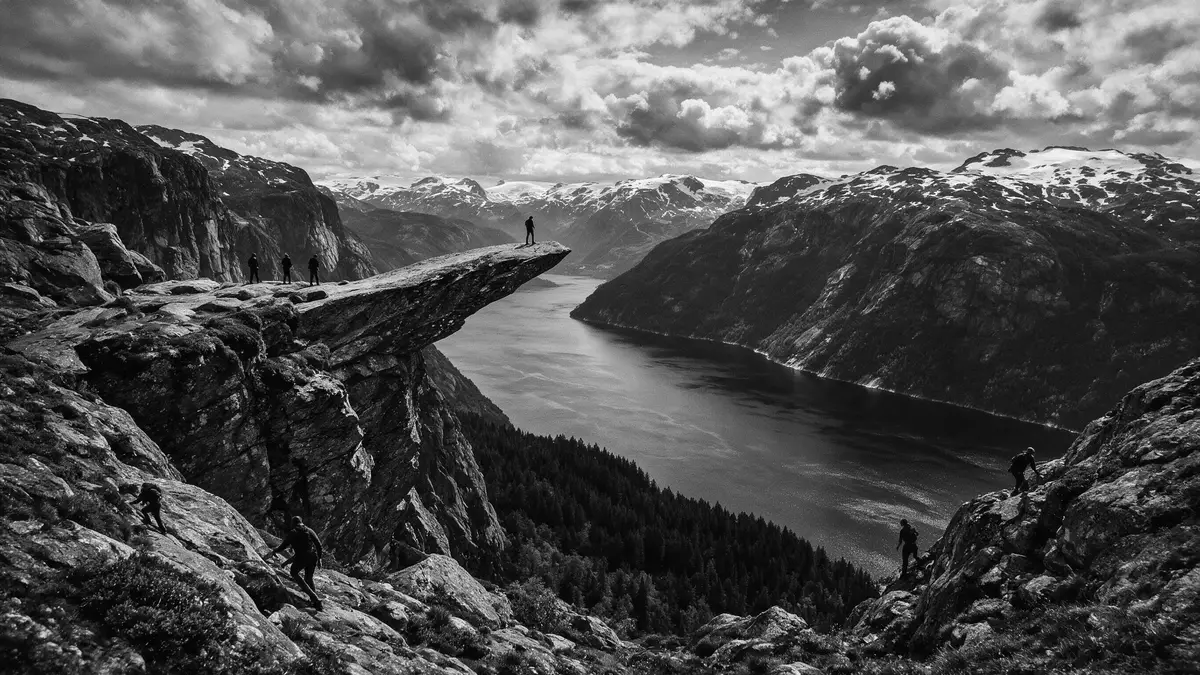
Trolltunga in Ullensvang is a horizontal cliff of ancient bedrock high in the mountains above Ringedalsvatnet in western Norway. The rock ledge projects from a steep mountainside in the Hardanger region and has become a landmark for long-distance hikers on Norway’s fjord plateau.
A horizontal rock ledge suspended above Ringedalsvatnet
Trolltunga is a rock formation in Vestland county in south-western Norway, within Ullensvang municipality in the Hardanger region.Ullensvang municipality in Vestland The ledge lies in the mountains above the long, narrow lake Ringedalsvatnet, in a landscape carved by glaciers and inland from the Hardangerfjord coastline.above the lake Ringedalsvatnet
The name Trolltunga translates as “Troll’s Tongue” in Norwegian and refers to the way the rock juts horizontally from the cliff, resembling a tongue extending over the valley.translates as Troll’s Tongue The ledge stands at an elevation of around 1,100–1,180 m (approximately 3,600–3,870 ft) above sea level and hangs about 700 m (around 2,300 ft) above the surface of Ringedalsvatnet, giving visitors a clear sense of height between rock and water.about 700 metres above the lake
Ancient gneiss shaped by ice and water
The bedrock forming Trolltunga is Precambrian gneiss, a hard metamorphic rock that formed more than a billion years ago during deep mountain-building processes in what is now western Norway.Precambrian gneiss bedrock Over geological time this bedrock was lifted and eroded, creating the high plateau above Ullensvang and the steep walls that descend towards Ringedalsvatnet.
The distinctive tongue-like shape of the ledge is linked to glacial erosion during the last Ice Age, when moving ice and meltwater exploited fractures in the gneiss and removed blocks of rock from the cliff face.glacial erosion during the last Ice Age The result is a relatively thin horizontal projection extending several metres out from the surrounding mountain, with vertical drops on three sides and views along the length of Ringedalsvatnet, framed by other summits on the Hardanger plateau.
A demanding mountain hike above the Hardanger region
Trolltunga is reached on foot from the mountain valley of Skjeggedal above the town of Tyssedal, near the head of the Hardangerfjord in Ullensvang.close to Odda in Hardanger The main trailhead lies near Skjeggedal and climbs through varied mountain terrain on marked paths before reaching the plateau above Ringedalsvatnet.the hike to Trolltunga starts in Skjeggedal
The approach is long and strenuous, with significant ascent from Skjeggedal to the elevation of the ledge, and it crosses exposed sections of mountain plateau. Weather at this altitude can change quickly, and large parts of the route pass over bare rock, boggy ground and sections of stone steps, so sturdy footwear and suitable clothing are essential for anyone planning the hike.
Visiting Trolltunga: what travellers from Western Europe should know
- Trolltunga lies in Ullensvang municipality in Vestland, inland from the Hardangerfjord, and the usual road access runs via Tyssedal and the valley of Skjeggedal.
- The hike from Skjeggedal climbs steeply onto a high mountain plateau, with long stretches on bare rock and alpine terrain that require good footwear and a solid level of fitness.
- The route to the ledge involves sustained elevation gain and a full-day outing on foot, so carrying adequate layers, food and water is important in any season.
- Snow can linger at higher elevations well into spring, and autumn can bring early frosts, so conditions underfoot vary across the hiking season.
- The official language is Norwegian and the currency is the Norwegian krone. Entry requirements depend on your nationality; UK travellers can check the FCDO travel advice at gov.uk/foreign-travel-advice, Irish travellers the Department of Foreign Affairs at ireland.ie.
Searching for Trolltunga on social platforms
These links open searches for Trolltunga on each platform.
Frequently asked questions about Trolltunga
Where is Trolltunga located?
Trolltunga is in Ullensvang municipality in Vestland county, in the Hardanger region of western Norway, above the lake Ringedalsvatnet and near the town of Tyssedal.
What should hikers expect on the route to Trolltunga?
The route from Skjeggedal is a long mountain hike with considerable ascent, exposed plateau sections and variable ground underfoot, requiring robust footwear, suitable clothing and good fitness.
What makes Trolltunga distinctive among Norwegian viewpoints?
Trolltunga is distinctive because it is a horizontal ledge of ancient gneiss projecting from a high cliff, hanging several hundred metres above Ringedalsvatnet with unobstructed views along the lake.


