
Trolltunga: Norway’s horizontal cliff above Ringedalsvatnet
Published on 08/21/2026 at 21:45 | Editorial responsibility: Rafael Müller, Editor-in-Chief AD HOC NEWS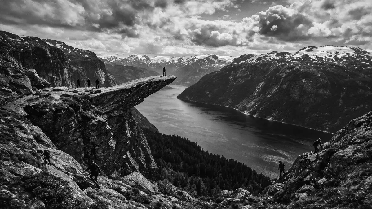
Trolltunga is a horizontal cliff ledge in the mountains above Ringedalsvatnet, in Ullensvang municipality in western Norway’s Hardanger region. The rock formation projects from the mountainside high above the lake, at an elevation of over 1,100 m (around 3,600 ft) above sea level, creating one of Norway’s most recognisable natural viewpoints.
A cliff like a stone tongue above Ringedalsvatnet
The name Trolltunga translates as “the troll’s tongue”, a reference to the narrow slab of rock that juts out from the mountain wall above the north side of Ringedalsvatnet.Trolltunga translates as “the troll’s tongue” The cliff forms part of a high mountain plateau shaped by glaciers, with bare bedrock and scattered pools between low ridges.The famous rock formation sits above Ringedalsvatnet
The ledge projects horizontally from the mountainside, hanging above the drop to the lake and facing a panorama of surrounding peaks and valleys. Seen from the approach, Trolltunga appears as a thin slice of rock against the sky, with Ringedalsvatnet stretching out below as a long, dammed mountain lake enclosed by steep rock walls.The ledge hangs about 700 m above the lake
Hardanger plateau and the setting above Ullensvang
Trolltunga lies in Vestland county, in the inland mountains behind the Hardangerfjord, near the small town of Odda and the village of Tyssedal in Ullensvang municipality.The cliff lies inland from the Hardangerfjord The plateau around the cliff forms part of the wider Hardangervidda area, where glaciers and meltwater carved wide valleys and left behind rounded summits and scoured rock.
The lake below the ledge, Ringedalsvatnet, is a long, narrow reservoir framed by steep slopes. From the rock, the water surface lies far below, and the line of the lake leads the eye along the valley towards more distant mountains. On clear days the scene combines bare grey rock underfoot, patches of lingering snow on higher ridges and the deep blue of the water in the basin below.Trolltunga stands on the western edge of the Hardangervidda plateau
A demanding full-day mountain hike
Reaching Trolltunga involves a high-mountain hike rather than a short stroll to a roadside lookout. The most used route begins at Skjeggedal above Tyssedal, where a mountain road and track lead up from the Sørfjorden arm of the Hardangerfjord into the uplands.The classic hike starts at P2 Skjeggedal From there, marked paths cross sections of steep ascent and long stretches of undulating plateau before reaching the viewpoint above Ringedalsvatnet.
The overall route from the main Skjeggedal trailhead covers well over 20 km (over 12 mi) there and back, with a total ascent of more than 800 m (about 2,600 ft).The out-and-back hike is a demanding full-day route The path traverses sections of stone steps, bare rock slabs and marshy ground, and much of the route lies above the treeline, exposed to mountain weather. Waymarkers and signposts guide hikers across the plateau to the cliff, where the narrow ledge becomes the turnaround point before the return along the same trail.
Visiting Trolltunga: what travellers from Western Europe should know
- Trolltunga lies in the municipality of Ullensvang in Vestland, inland from the Hardangerfjord and reached from the small town of Odda and the village of Tyssedal.
- The usual trailhead for the main hiking route is at Skjeggedal above Tyssedal, reached by road that climbs from the fjord valley into the mountains.
- The hike is a long mountain route on exposed high plateau terrain, with sustained ascent, stone steps and long stretches on bare rock above the treeline.
- Weather in the mountains around Trolltunga can change quickly, and conditions at over 1,000 m (3,281 ft) differ from those down by the fjord.
- Norway’s official language is Norwegian and the currency is the Norwegian krone.
Searching for Trolltunga on social platforms
These links open searches for Trolltunga on each platform.
Frequently asked questions about Trolltunga
Where is Trolltunga?
Trolltunga is in Ullensvang municipality in Vestland county in western Norway, in the inland mountains above the Sørfjorden arm of the Hardangerfjord.
What should visitors expect on a hike to Trolltunga?
The hike is a demanding full-day mountain route from Skjeggedal above Tyssedal, with long distances, significant ascent and exposed high-plateau terrain above the treeline.
What makes Trolltunga distinctive?
Trolltunga is distinctive for its horizontal rock ledge projecting high above Ringedalsvatnet, combining a dramatic overhanging viewpoint with wide views of Norway’s glacial mountain landscape.


