
Uluru’s sandstone monolith in Australia’s Red Centre
Published on 08/24/2026 at 07:37 | Editorial responsibility: Rafael Müller, Editor-in-Chief AD HOC NEWS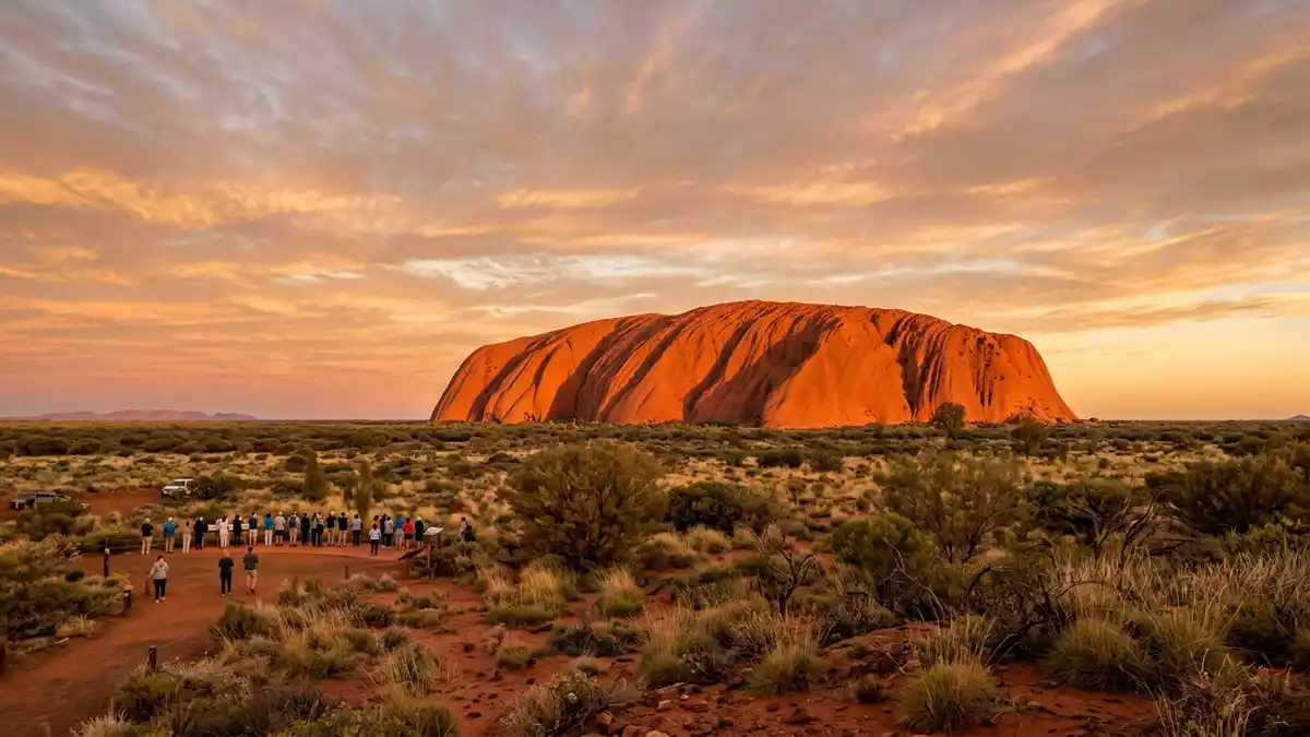
Uluru is a sandstone monolith rising above the desert plains of central Australia, near the settlement of Yulara in the Northern Territory. It anchors Uluru-Kata Tjuta National Park, a World Heritage landscape shaped by deep geological time and the living culture of the Anangu people.
A sandstone giant in Australia’s Red Centre
Seen from the surrounding sandplains, Uluru appears as a single, immense rock massif, its red-brown faces rising sharply from relatively flat country. The formation is composed of arkosic sandstone, a coarse rock with visible feldspar grains, weathered into steep flanks and shallow gullies that catch changing light across the day.arkosic sandstone The monolith reaches about 348 m (1,142 ft) above the surrounding plain and around 863 m (2,831 ft) above sea level, with much of its bulk extending underground beyond the visible perimeter.348 m above the surrounding plain
Uluru’s outline is rounded rather than jagged, with long slopes, ledges and weathered runnels descending from the crest towards a base that measures roughly 9.4 km (5.8 mi) in circumference.9.4 kilometres in circumference The rock’s colour varies with the angle of the sun, from deeper reds and browns when low light skims the faces to paler tones when the sun sits high. Around Uluru stretch sand dunes, sparse woodland and desert vegetation, reinforcing the sense of a solitary massif in an otherwise open landscape.
Anangu country and a living cultural landscape
Uluru lies within the traditional lands of the Pitjantjatjara and Yankunytjatjara peoples, who refer to themselves collectively as Anangu. For Anangu, the rock and the wider national park form a cultural landscape governed by Tjukurpa, often glossed in English as “law”, which connects ancestral beings, the land, its features and community responsibilities.traditional lands of Pitjantjatjara and Yankunytjatjara peoples Numerous features of Uluru and nearby Kata Tjuta are associated with specific Tjukurpa stories, and these associations guide both cultural practice and park management.
Uluru-Kata Tjuta National Park is jointly managed as Aboriginal land by Anangu and Parks Australia under agreements that recognise both its natural and cultural values.jointly managed by Anangu and Parks Australia The park was inscribed on the World Heritage List in two stages, first in 1987 for outstanding universal natural values and later, in 1994, for its cultural significance as a living landscape shaped by Anangu law and land use.World Heritage List in two stages For travellers, this means that visible geological features, plant communities and walking routes sit within a framework of custodianship in which traditional knowledge remains central.
Exploring Uluru and its surrounding desert
The settlement of Yulara lies to the north-east of Uluru and serves as the main service village for visitors to Uluru-Kata Tjuta National Park.PO Box 119 Yulara NT 0872 From Yulara, the park road network leads towards viewing areas and parking zones near the base of the monolith. Around Uluru, formed paths give access to sections of the perimeter, passing close to rock faces, vegetated pockets and occasional waterholes set into recesses where runoff gathers after rainfall.
Within the park, Uluru and the domes of Kata Tjuta rise above a largely flat sandplain environment scattered with desert shrubs, grasses and occasional stands of trees.sandplains and woodland environment The contrast between expansive horizontal terrain and the vertical mass of the rock is central to its visual character. Certain areas around the base are designated as culturally sensitive and photography restrictions apply there; other sections present broad views of the faces, enabling close observation of bedding planes, weathering streaks and surface textures that record long geological processes.
Visiting Uluru: what travellers from Western Europe should know
- Uluru lies in Uluru-Kata Tjuta National Park in Australia’s Northern Territory, with access routes and visitor facilities centred on Yulara, reached by road and air services.
- The terrain around Uluru combines sealed roads with stretches of desert track and walking paths at the rock’s base, including exposed sections where shade is limited.
- Seasonal temperatures in central Australia can be high, and walking near Uluru takes place in an arid environment with sandy surfaces and minimal shelter away from designated rest areas.
- The official language is English and the currency is the Australian dollar.
- Entry requirements depend on your nationality; UK travellers can check the FCDO travel advice at gov.uk/foreign-travel-advice, Irish travellers the Department of Foreign Affairs at ireland.ie.
Searching for Uluru on social platforms
These links open searches for Uluru on each platform.
Frequently asked questions about Uluru
Where is Uluru and how is it protected?
Uluru stands in central Australia within Uluru-Kata Tjuta National Park, in the Northern Territory, and is protected as Aboriginal land under joint management arrangements.
What should travellers expect when visiting Uluru?
Travellers encounter an arid desert environment, a large sandstone monolith with formed paths at its base, and a park framework that places Anangu custodianship at the centre of visitor information.
What makes Uluru distinctive among rock formations?
Uluru is distinctive for its size as a single sandstone monolith, its red-brown faces rising above flat sandplains, and its recognised status as both a geological feature and a cultural landscape.


