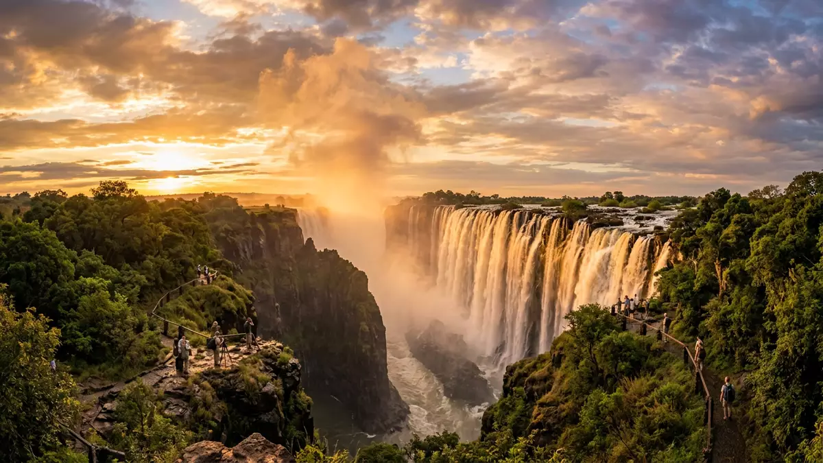
Victoria Falls and the basalt gorge that shapes it
Published on 08/12/2026 at 13:48 | Editorial responsibility: Rafael Müller, Editor-in-Chief AD HOC NEWS
Victoria Falls is a broad curtain of water on the Zambezi River where the river plunges from a basalt plateau into a narrow chasm between Zambia and Zimbabwe. The waterfall lies near the town of Victoria Falls in north-western Zimbabwe and Livingstone on the Zambian side, anchoring a landscape where river, cliffs and rainforest meet along the Zambia–Zimbabwe border.
A basalt plateau cut by a river
The defining feature of Victoria Falls is the way the Zambezi River encounters a hard volcanic plateau and drops suddenly into a gorge. The falls mark the point where the river flows over a sheet of dark basalt and then plunges more than 100 m (around 330 ft) into a trench carved into the rock.Maximum drop of 108 m The basalt in the area belongs to the Karoo volcanic sequence and forms steep cliffs within the Batoka Gorge below the waterfall.Karoo-age Batoka basalt in the gorges
Upstream of the brink the Zambezi flows in a relatively shallow valley bordered by low sandstone hills, then reaches the hard basalt edge and spills in a nearly continuous line into the gorge below.Zambezi over basalt with sandstone margins The waterfall itself extends for around 1,700 m (about 1.7 km) across the river’s width when the river is in full flood, creating one of the largest sheets of falling water documented anywhere.World’s largest sheet of falling water
Gorges, cracks and the retreat of the falls
Below Victoria Falls the river enters Batoka Gorge, a series of zigzag chasms cut into the basalt plateau. Geological studies describe large east–west cracks within the basalt, filled with weaker sandstone, linked by smaller north–south fractures.Sandstone-filled cracks in basalt Over many thousands of years, the river has eroded the softer material, opening up successive gorges and shifting the waterfall’s line upstream as each previous cliff has collapsed.Retreat through Batoka Gorge
Standing at the rim today, a visitor looks across the present fall line and, downstream, into a gorge that forms the beginning of a deep trough extending for many kilometres. The walls of this trough reach depths of around 120 to 240 m (400 to 800 ft), cut into the basalt as the river has carved its path.Depth of Batoka Gorge below Behind the current waterfall, traces of earlier fall positions can be read in the sequence of gorges, each marking a stage in the river’s long interaction with the plateau.
Mosi-oa-Tunya and the protected rainforest
Victoria Falls is known locally by names that describe its character: in Lozi, “Mosi-oa-Tunya” translates as “Smoke that Thunders”, referring to the spray cloud and the sound of water striking the gorge.Mosi-oa-Tunya, Smoke that Thunders The falls and the surrounding area on both sides of the river are recognised as a World Heritage Site, shared by Zambia and Zimbabwe, highlighting their geological and cultural significance.Mosi-oa-Tunya / Victoria Falls inscription
On the Zimbabwean side, Victoria Falls National Park protects a belt of riverine rainforest that owes its existence to the constant spray from the waterfall.Victoria Falls National Park rainforest Paths and viewpoints follow the edge of the gorge, giving different angles on the main curtain of water and the individual channels that make up the falls, while the spray-fed forest, rocky cliffs and river together form the immediate surroundings of the site.
Visiting Victoria Falls: what travellers from Western Europe should know
- Victoria Falls lies on the Zambezi River at the border between Zambia and Zimbabwe, reached from the town of Victoria Falls on the Zimbabwean side and Livingstone in Zambia.
- The terrain around the waterfall includes cliff-edge paths and viewpoints above the gorge, with sections where spray can make surfaces wet and where the ground drops steeply towards the river.
- The official languages are English in both Zambia and Zimbabwe, and the currencies are the Zambian kwacha and the Zimbabwean dollar.
- Entry requirements depend on your nationality; UK travellers can check the FCDO travel advice at gov.uk/foreign-travel-advice, Irish travellers the Department of Foreign Affairs at ireland.ie.
Searching for Victoria Falls on social platforms
These links open searches for Victoria Falls on each platform.
Frequently asked questions about Victoria Falls
Where is Victoria Falls located?
Victoria Falls is on the Zambezi River along the border between Zambia and Zimbabwe in southern Africa, near the town of Victoria Falls and Livingstone.
What should visitors expect when viewing the falls?
Visitors encounter a wide waterfall dropping into a narrow basalt gorge, with viewpoints along the rim where spray, rock faces, forest and river are all part of the setting.
What makes Victoria Falls distinctive among waterfalls?
Victoria Falls combines a fall line about 1.7 km long with a maximum height of about 108 m, creating a documented large sheet of falling water above a deep basalt gorge.