
Volcan Pacaya: a constantly reshaping Guatemalan volcano
Published on 08/17/2026 at 13:05 | Editorial responsibility: Rafael Müller, Editor-in-Chief AD HOC NEWS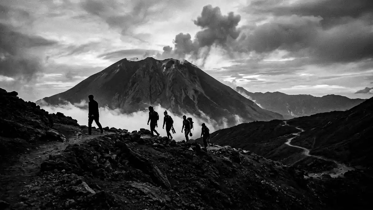
Volcan Pacaya in Escuintla, Guatemala is an active volcano whose profile, slopes and craters have been reshaped repeatedly by eruptions and lava flows over thousands of years. Rising to more than 2,500 m (about 8,300 ft) above sea level, it stands within Pacaya National Park and above the village of San Vicente Pacaya in a landscape of forested ridges and agricultural valleys.
A complex volcanic cone above Escuintla
Pacaya is part of the Central Highlands of Guatemala, forming a complex volcano built from overlapping cones, domes and lava flows on the edge of an older caldera linked with Lake Amatitlán.complex volcano built from overlapping cones Its summit elevation is reported at about 2,552 m (8,373 ft), with coordinates close to 14.38° N, 90.60° W, placing it south of Guatemala City and within Escuintla Department.summit elevation and coordinates The volcano forms a broad, conical mass rising above the surrounding hills, with younger basaltic structures resting against remnants of older stratovolcanoes.
The structure of Pacaya includes several named peaks and cones such as Cerro Chino, Cerro Grande and the MacKenney cone, which has been the focus of recent eruptive activity within a pit crater near the summit.summit data for Pacaya On its flanks, hardened basaltic and andesitic lava flows form dark bands and ridges, while older deposits of tephra and ash have weathered into soils supporting forest and small-scale farming. From accessible viewpoints on the national park trails, visitors see the main cone rising above a field of solidified lava and scattered volcanic blocks.
An active history in the Central America Volcanic Arc
Geologically, Pacaya belongs to the Central America Volcanic Arc, a chain of volcanoes formed above the subduction zone where the Cocos Plate descends beneath the Caribbean Plate.Central America Volcanic Arc context The Pacaya complex is thought to date from around 23,000 years ago, when volcanic activity began building the present edifice on the margin of the older Amatitlán caldera.formation on the edge of an older caldera Since the Spanish conquest of Guatemala in the sixteenth century, Pacaya has had numerous historically documented eruptions, with records listing many episodes from the 1500s onwards.
The twentieth century marked a change in Pacaya’s behaviour, with a long repose ending in the early 1960s when renewed eruptive activity began from the summit area.twentieth-century activity description Since the 1960s, the volcano has shown frequent strombolian activity, producing incandescent bombs, ash emissions and short lava flows from its active crater. Databases tracking eruptions list dozens of events between 1900 and 2021, with the most recent multi-year eruptive phase running from 2015 to 2021.eruption record and recent phase This sustained record of activity has led to Pacaya being regarded as one of Guatemala’s most active volcanoes, a status reflected in its national park designation.
Pacaya National Park and the trail from San Vicente Pacaya
Volcan Pacaya sits within Pacaya National Park, which encompasses the volcano and the Laguna de Calderas area across the municipalities of Amatitlán and San Vicente Pacaya in the departments of Guatemala and Escuintla.Pacaya National Park and Laguna de Calderas The park’s extent covers more than 1,000 hectares of volcanic terrain, including forested slopes, lava fields and the crater lake within the caldera. Within this protected landscape, a network of trails provides access to viewpoints over the active cone and the surrounding highlands.
The main access route to Pacaya National Park follows the CA-9 Sur road from Guatemala City towards the Pacific coast, turning towards the municipality of San Vicente Pacaya near kilometre 37.CA-9 Sur access route The standard hiking trail begins near San Vicente Pacaya and climbs across volcanic ash and rock to viewpoints on the upper slopes above 2,400 m elevation.trail starting near San Vicente Pacaya From these vantage points, travellers look across the active cone, see hardened lava fields and, in clear conditions, distant views towards other volcanoes of the Guatemalan highlands.
Visiting Volcan Pacaya: what travellers from Western Europe should know
- Volcan Pacaya stands in the Central Highlands of Guatemala, within Escuintla Department, south of Guatemala City and reached by road via the CA-9 Sur towards San Vicente Pacaya.
- The standard trail from San Vicente Pacaya climbs over volcanic ash and uneven rock to viewpoints on the upper slopes, with sustained gradients and sections of loose underfoot material.
- Pacaya lies within Pacaya National Park, which also includes the Laguna de Calderas caldera lake and forested volcanic slopes in the municipalities of Amatitlán and San Vicente Pacaya.
- The official language is Spanish and the currency is the Guatemalan quetzal.
- Entry requirements depend on your nationality; UK travellers can check the FCDO travel advice at gov.uk/foreign-travel-advice, Irish travellers the Department of Foreign Affairs at ireland.ie.
Searching for Volcan Pacaya on social platforms
These links open searches for Volcan Pacaya on each platform.Frequently asked questions about Volcan Pacaya
Where is Volcan Pacaya located?
Volcan Pacaya is in Escuintla Department in southern Guatemala, within Pacaya National Park, south of Guatemala City and near the municipality of San Vicente Pacaya.
What can travellers expect on a visit to Pacaya?
Travellers encounter a volcanic landscape of ash, hardened lava flows and forested slopes, with trails from San Vicente Pacaya climbing to viewpoints overlooking the active cone and surrounding highlands.
What makes Volcan Pacaya distinctive among Guatemalan volcanoes?
Pacaya is distinctive for its sustained record of strombolian activity over recent decades, its complex structure of overlapping cones and domes, and its setting within a national park that preserves both active volcanic features and the wider caldera landscape.


