
Whitehaven Beach and the shifting sands of Hill Inlet
Published on 09/24/2026 at 10:58 | Editorial responsibility: Rafael Müller, Editor-in-Chief AD HOC NEWS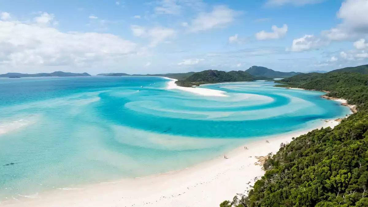
Whitehaven Beach is a long sweep of bright silica sand on the south-eastern side of Whitsunday Island in Queensland’s Whitsundays. The beach extends for about 7 km, while Hill Inlet at its northern end brings tidal water across pale sandbanks in changing bands of white, blue and green.
Whitehaven Beach: a long shore of silica sand
The beach’s defining material is fine silica sand. Descriptions place its silica content at about 98 per cent, giving the shore its light colour and soft, powder-like texture. The sand differs from coarser beaches in the Whitsundays, where shell and coral fragments form a larger part of the surface. Whitehaven’s silica sand runs beside shallow water and low coastal vegetation.
The sand is not derived from large local quartz deposits. Queensland Parks describes a geological history involving silica-rich material carried northwards along the Queensland coast by sea currents, followed by the removal of impurities through fresh water. The most recent rise in sea level, about 10,000 years ago, brought the sea to the foot of the dunes and formed the shoreline recognised as Whitehaven Beach.
Hill Inlet and the geography of Whitsunday Island
Hill Inlet lies at the northern end of Whitehaven Beach, between the beach and Tongue Point. Tidal water moves across submerged and exposed sandbanks, producing broad patterns that change with the tide. From the headland above the inlet, the shore appears as overlapping sweeps of pale sand and aquamarine water.
Whitsunday Island is the largest island in the Whitsunday group. Its forested slopes, rocky headlands and coastal vegetation frame the beach, while the Coral Sea opens beyond the eastern shore. The island is a continental island, formed from land once connected to mainland Queensland rather than from a coral cay. The Whitsundays’ geological history reaches back to volcanic activity and changing sea levels.
Hill Inlet gives the beach a second visual language. Whitehaven is a broad, open shoreline, while the inlet is a network of tidal channels and sandbars. Both features are made from the same pale sediment, but water arranges it differently at the northern end.
Protected landscape and Ngaro sea Country
Whitehaven Beach lies within Whitsunday Islands National Park and the Great Barrier Reef World Heritage Area. The surrounding marine environment forms part of the Great Barrier Reef Marine Park, linking the beach with island forests, fringing reefs and shallow coastal waters. Whitsunday Islands National Park protects the land around the beach.
The Whitsundays are the traditional home of the Ngaro Aboriginal people, also known as the Canoe People. Archaeological research records Ngaro occupation in the island group for at least 9,000 years. Evidence across the islands includes stone tools, fish traps, shell middens and rock art, while Nara Inlet on Hook Island contains a recognised Ngaro cultural site. Ngaro history in the Whitsundays places the beach within a wider cultural landscape.
James Cook entered the Whitsundays in 1770 during his voyage along the Queensland coast. European settlement and timber activity followed in the nineteenth century, while many Ngaro people were forcibly removed from their homeland from the 1880s onwards. The national park and marine park designations preserve a landscape with geological, ecological and cultural dimensions.
Visiting Whitehaven Beach: what travellers from Western Europe should know
- Whitehaven Beach lies offshore from Queensland’s central coast, east of Airlie Beach. Access is by boat, canoe or kayak, with commercial operators and private vessels departing from Airlie Beach or Shute Harbour.
- The beach is reached from the water, and walking tracks lead towards lookouts above Hill Inlet and the surrounding coast. The sand, forested slopes and headland tracks create a landscape of shoreline, vegetation and uneven ground.
- Tongue Bay is the nearest public mooring for the Whitehaven Beach day-use area. Hill Inlet is at the northern end of the beach, while the beach itself occupies the island’s south-eastern side.
- The official language is English and the currency is the Australian dollar.
- Entry requirements depend on your nationality; UK travellers can check the FCDO travel advice at gov.uk/foreign-travel-advice, Irish travellers the Department of Foreign Affairs at ireland.ie.
Searching for Whitehaven Beach on social platforms
These links open searches for Whitehaven Beach on each platform.Frequently asked questions about Whitehaven Beach
Where is Whitehaven Beach?
Whitehaven Beach is on Whitsunday Island, off Queensland’s central coast in Australia. It lies within Whitsunday Islands National Park and the Great Barrier Reef World Heritage Area.
What can visitors expect at Whitehaven Beach?
Visitors encounter a long silica-sand shoreline, shallow coastal water, forested island slopes and walking tracks towards headland lookouts. Boat access connects the beach with Airlie Beach and Shute Harbour.
What makes Whitehaven Beach distinctive?
About 98 per cent of the sand is silica, and the beach extends for about 7 km. At Hill Inlet, tidal channels move across the sandbanks and create changing patterns at the northern end.


