
Yaxha rises along a forested ridge beside Lake Yaxha
Published on 09/24/2026 at 04:11 | Editorial responsibility: Rafael Müller, Editor-in-Chief AD HOC NEWS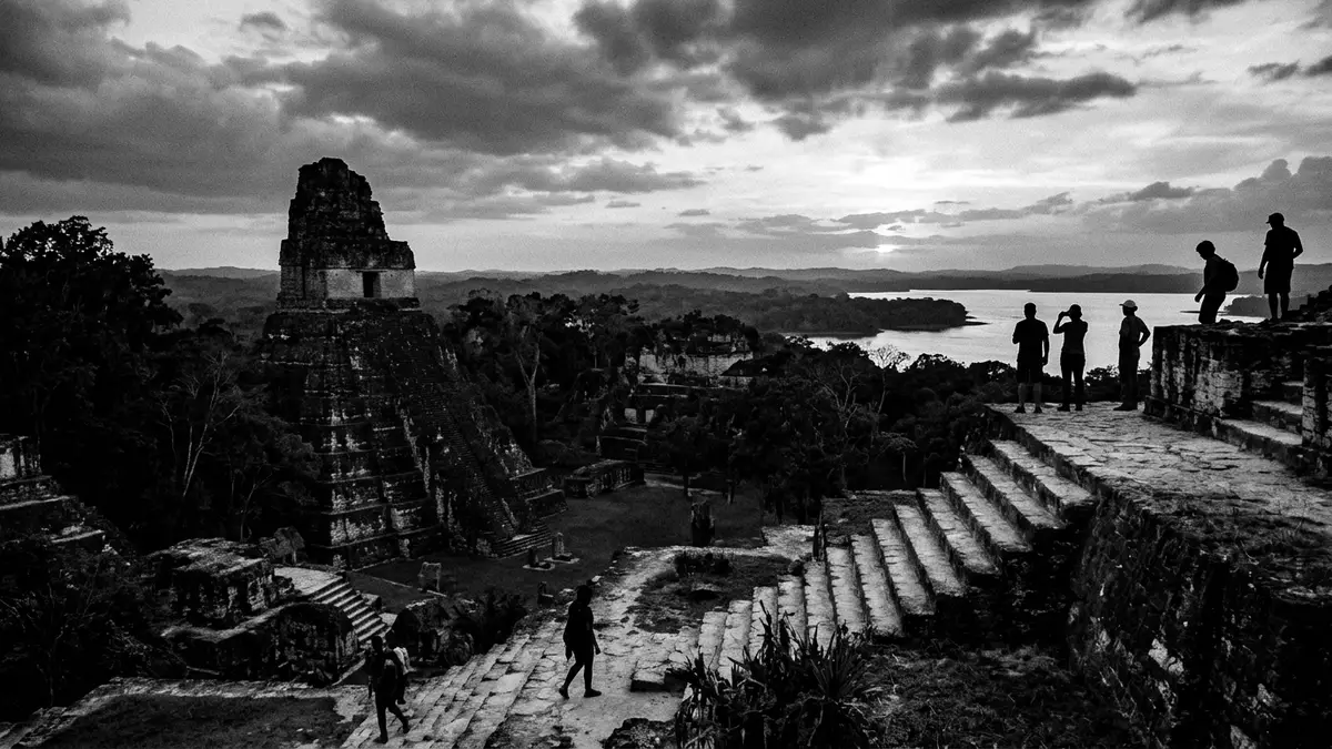
Yaxha is a Maya archaeological site in Guatemala’s northern Petén, arranged along a forested ridge beside Lake Yaxha. Its temples, palaces and causeways occupy a long landscape between water and lowland forest, giving the ancient city a distinctly linear form.
Yaxha and the long Maya occupation of Petén
Settlement at Yaxha began during the Middle Preclassic period, several centuries before the Common Era. The city grew through the Classic period and remained part of the political and ceremonial world of the Maya for more than a millennium.
The site reached its greatest development during the Early Classic period, from about AD 250 to 600. Its history continued into the Late Classic period, when Yaxha formed part of a regional network that included Naranjo and Nakum. The hieroglyphic name Yaxha is associated with green or blue-green water, a fitting reference to the adjacent lake.
Archaeologists have recorded more than 500 structures across the site. These include temple platforms, palaces, residential compounds, administrative buildings, ball courts and carved monuments. The scale places Yaxha among the major Maya centres of the eastern Petén.
Temples, causeways and the ridge above the lake
The urban area follows elevated ground beside Lake Yaxha and extends through the surrounding forest. Its principal groups are connected by raised causeways, known in Maya studies as sacbeob. These routes link plazas, courtyards and monumental buildings across the ridge.
The Main Acropolis contains pyramidal architecture, palace buildings and broad plaza spaces. The North Acropolis, also known as the Maler group, forms another large architectural complex. The East Acropolis includes ceremonial structures and the distinctive twin pyramid complexes associated with Maya calendrical monuments.
Stone stelae and altars stand among the architectural groups. Their inscriptions and carved surfaces belong to the written and visual record of Maya rulership. The site also contains ball courts, where architectural form identifies a formal element of Maya civic and ceremonial life.
The lake remains visible from elevated parts of the ruins, while the forest surrounds the archaeological zone. Water, stone platforms and tree-covered slopes appear together across the site, making the relationship between settlement and landscape one of Yaxha’s defining features.
A Maya city within the Yaxha-Nakum-Naranjo landscape
Yaxha forms part of the Yaxha-Nakum-Naranjo National Park in the Petén region. The protected landscape includes archaeological sites, wetlands, lakes and tropical forest. Yaxha, Nakum and Naranjo belong to the same wider cultural region, although each site has its own architectural groups and historical record.
The surrounding forest contains the ecological setting of the Maya lowlands, with broadleaf trees, wetland vegetation and wildlife habitats. Lake Yaxha and nearby Lake Sacnab define the water-rich environment around the ruins. The archaeological remains are therefore encountered as buildings distributed through a living landscape, not as a single enclosed monument.
Yaxha’s surviving architecture records several centuries of construction and use. Earlier platforms, later monumental groups and connecting causeways form a layered urban plan. The site’s ridge, lakeside position and forest setting remain legible in the arrangement of its plazas and temples.
For travellers staying in Flores, Yaxha offers a different archaeological setting from the larger inland centres of Petén. Its principal visual relationship is with Lake Yaxha, while its built remains extend along the ridge and into the woodland around it.
Visiting Yaxha: what travellers from Western Europe should know
- Yaxha lies in northern Guatemala’s Petén region, east of Flores. Road access follows the route towards the Belize border, with a turn-off leading to the national park and archaeological zone.
- The site extends across forested and uneven ground. Visits involve walking between plazas, causeways, acropolises and temple platforms, with stairs on several monumental structures.
- Lake Yaxha borders the archaeological landscape, while Lake Sacnab lies nearby. The route through the ruins combines open plazas, raised paths, woodland and elevated viewpoints.
- The official language is Spanish and the national currency is the Guatemalan quetzal.
- Entry requirements depend on your nationality; UK travellers can check the FCDO travel advice at gov.uk/foreign-travel-advice, Irish travellers the Department of Foreign Affairs at ireland.ie.
Searching for Yaxha on social platforms
These links open searches for Yaxha on each platform.
Frequently asked questions about Yaxha
Where is Yaxha?
Yaxha is in the Petén region of northern Guatemala, east of Flores. The ruins lie beside Lake Yaxha within the Yaxha-Nakum-Naranjo National Park.
What can visitors see at Yaxha?
The archaeological zone contains temples, palaces, acropolises, causeways, ball courts, stelae and altars. Paths cross forested ground between plazas and elevated architectural groups.
What makes Yaxha distinctive?
Its Maya architecture follows a forested ridge beside Lake Yaxha. The combination of water, monumental stone buildings and long connecting causeways defines the site.


