
Uluru’s sandstone giant near Yulara
Published on 09/07/2026 at 06:28 | Editorial responsibility: Rafael Müller, Editor-in-Chief AD HOC NEWS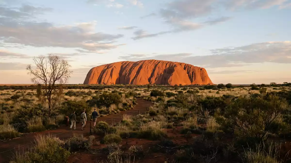
Uluru in central Australia is a single mass of rust-coloured sandstone rising above the desert plain near Yulara, a landmark where geology and Aboriginal tradition meet in one striking form. The rock stands around 348 m (1,142 ft) above the surrounding plain and reaches about 863 m (2,831 ft) above sea level, with a base circumference close to 9.4 km (5.8 miles), so it reads on the ground as a long, blunt-sided ridge rather than a compact peak.
A sandstone monolith in Australia’s Red Centre
Uluru lies in the Northern Territory, within Uluru-Kata Tjuta National Park, in the desert interior often called Australia’s Red Centre, where low scrub, sandy soils and distant horizons emphasise the rock’s scale.Uluru-Kata Tjuta National Park The sandstone body forms an inselberg, an isolated hill rising sharply from relatively flat erosion lowlands in a hot, dry region, so it dominates views across the central interior of Australia from many kilometres away.insulated sandstone hill
Geologists describe Uluru as arkose sandstone, a coarse rock rich in feldspar grains that weather to a reddish surface, which explains the deep rust colour under daylight and the glowing tones around dawn and dusk.arkose sandstone composition The exposed length of the rock is about 3.6 km (2.2 miles), with a width around 1.9 km (1.2 miles), and the visible mass is anchored to a larger body of sandstone that extends several kilometres underground, so only a fraction of the total rock body appears above the plain.dimensions of Uluru
Surfaces, gullies and waterholes around the base
Walking around Uluru’s base reveals how varied a single block of sandstone can be, with sheer faces, gentler slopes, deep gullies and recesses broken by ledges and overhangs rather than one simple uniform wall.exposed length and width Sections of the rock carry streaks and dark stains left by rainwater as it runs down from the summit, tracing gravity-shaped lines across the sandstone and marking patterns that repeat along several faces of the monolith.streaked sandstone faces
At the foot of the rock, shaded recesses, small caves and water-worn gullies form a network of natural shelters where vegetation gathers more thickly than on the open plain, and where waterholes such as Mutitjulu collect runoff from larger catchments on the upper slopes.waterholes and base walk Around the perimeter, a level walking track follows the base of Uluru for roughly the 9.4 km circumference, crossing areas where fine sand meets the rock face, passing pockets of desert trees and shrubs, and approaching sites marked as culturally sensitive where photography and access are restricted by park guidelines.
Anangu country and a World Heritage landscape
Uluru sits within country cared for by the Anangu people, including the Pitjantjatjara and Yankunytjatjara, whose connection to the rock and the surrounding lands is expressed through Tjukurpa, often translated as “law”, “story” and “custom” together.Anangu traditional owners For Anangu, specific features of Uluru’s surface and base, such as particular caves, overhangs and waterholes, correspond to events and beings in Tjukurpa, so the visible sandstone forms carry layered meaning in addition to their geological character.
Uluru and the broader Uluru-Kata Tjuta National Park hold a dual listing on the UNESCO World Heritage list, first recognised in 1987 for natural values and again in 1994 for cultural significance, reflecting both its physical form and its place in living tradition.UNESCO World Heritage designations The park is jointly managed by Parks Australia and Anangu traditional owners, and the arrangement means that formal management decisions sit alongside customary responsibility for country, linking modern conservation practice with long-established care for the land.
Visiting Uluru: what travellers from Western Europe should know
- Uluru lies in Australia’s Northern Territory, south-west of Alice Springs, and is reached by road and air services connecting Yulara with other Australian towns and cities.
- The terrain around the rock consists of level desert tracks on sandy soil, together with short, sometimes uneven paths close to gullies, waterholes and shaded recesses at the base.
- Temperatures in the region can reach high daytime values and fall noticeably at night, so clothing and water supplies need to match a hot, dry interior climate.
- The official language is English and the currency is the Australian dollar.
- Entry requirements depend on your nationality; UK travellers can check the FCDO travel advice at gov.uk/foreign-travel-advice, Irish travellers the Department of Foreign Affairs at ireland.ie.
Searching for Uluru on social platforms
These links open searches for Uluru on each platform.
Frequently asked questions about Uluru
Where is Uluru and what kind of place is it?
Uluru is a large sandstone inselberg in Australia’s Northern Territory, near the service settlement of Yulara and within Uluru-Kata Tjuta National Park.
What should visitors expect on a visit to Uluru?
Visitors encounter a single sandstone mass several kilometres long, with varying faces, gullies and waterholes at its base and desert tracks around its perimeter.
What makes Uluru distinctive among desert landscapes?
Uluru’s combination of arkose sandstone geology, inselberg form, deep Anangu cultural significance and dual UNESCO World Heritage status gives the rock a character that is both physical and cultural.


